IMAGES TAKEN NEAR TO
Warningcamp, ARUNDEL, BN18 9QT
Introduction
This page details the photographs taken nearby to BN18 9QT by members of the Geograph project.
The Geograph project started in 2005 with the aim of publishing, organising and preserving representative images for every square kilometre of Great Britain, Ireland and the Isle of Man.

There are currently over 7.5m images from over14,400 individuals and you can help contribute to the project by visiting https://www.geograph.org.uk
Image Map
Images are licensed for reuse under creativecommons.org/licenses/by-sa/2.0
Notes
- Clicking on the map will re-center to the selected point.
- The higher the marker number, the further away the image location is from the centre of the postcode.
Image Listing (42 Images Found)
Images are licensed for reuse under creativecommons.org/licenses/by-sa/2.0
Image
Details
Distance
1
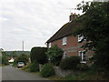
223, Warningcamp Lane, Warningcamp
A 17th cottage on the north side of the village street which has been refaced with brick. At the far end of the street is Image
Image: © Simon Carey
Taken: 20 Aug 2013
0.01 miles
2
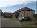
Norfolk Flint Barn, Warningcamp Lane, Warningcamp
An 19th century flint barn that was converted into a dwelling in 1993. The Norfolk part of the name derives from the local landowners, the Dukes of Norfolk, who probably constructed it.
Image: © Simon Carey
Taken: 20 Aug 2013
0.02 miles
3
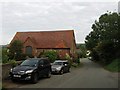
The Granary, Warningcamp Lane, Warningcamp
Built in the 19th century by the local landowner, the Duke of Norfolk, in the style of a medieval tithe barn. There are similar types of barns in Wepham, see Image and North Stoke. The barn has been converted into a residence.
Image: © Simon Carey
Taken: 20 Aug 2013
0.02 miles
4
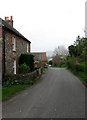
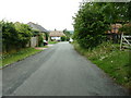
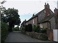
The Street
Main village street running down the hill towards the junction with the Burpham Road.
Image: © Simon Carey
Taken: 13 Apr 2009
0.02 miles
5
Recently thatched roof on cottage
At the bottom end of The Street.
Image: © Dave Spicer
Taken: 25 Jun 2011
0.03 miles
6
Christmas Cottage, Warningcamp
Seventeenth century or earlier timber-framed building, grade 2 listed http://www.britishlistedbuildings.co.uk/en-414755-christmas-cottage-warningcamp
Image: © Paul Gillett
Taken: 24 May 2012
0.03 miles
7
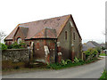
Converted Chapel, The Street
Least I think it is. On the main village street as it heads down to the junction with the Burpham Road.
Image: © Simon Carey
Taken: 13 Apr 2009
0.03 miles
8
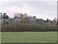
The hamlet of Warningcamp, seen from the Burpham road
The road runs along the eastern margin of the Arun flood-plain, the hamlet stands on higher ground.
After months with very limited rainfall, it was clear that heavy rain had fallen here in the previous 24 hours - and there was more on the way.
Image: © Stefan Czapski
Taken: 2 Nov 2011
0.03 miles
9
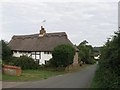
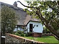
Christmas Cottage, Warningcamp Lane, Warningcamp
The thatched cottage dates from the 16th century though a stone on the wall facing the lane has the date 1772 on it, probably the date it was refaced and filled with flints.
Image: © Simon Carey
Taken: 20 Aug 2013
0.04 miles
10
River Coppice, Warningcamp Lane, Warningcamp
The flint cottage was built in 1790 and is located on the main village street. Just visible beyond is Image
Image: © Simon Carey
Taken: 20 Aug 2013
0.05 miles