IMAGES TAKEN NEAR TO
Crossbush Lane, ARUNDEL, BN18 9PQ
Introduction
This page details the photographs taken nearby to Crossbush Lane, BN18 9PQ by members of the Geograph project.
The Geograph project started in 2005 with the aim of publishing, organising and preserving representative images for every square kilometre of Great Britain, Ireland and the Isle of Man.

There are currently over 7.5m images from over14,400 individuals and you can help contribute to the project by visiting https://www.geograph.org.uk
Image Map
Images are licensed for reuse under creativecommons.org/licenses/by-sa/2.0
Notes
- Clicking on the map will re-center to the selected point.
- The higher the marker number, the further away the image location is from the centre of the postcode.
Image Listing (40 Images Found)
Images are licensed for reuse under creativecommons.org/licenses/by-sa/2.0
Image
Details
Distance
2
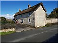
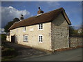
Calcetto Cottage, Crossbush Lane, West Sussex
Traditional built house, cob and thatch.
Image: © Jeff Gogarty
Taken: 20 Oct 2022
0.01 miles
3
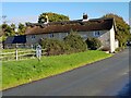
Traditional built house, cob and thatch, Crossbush Lane
Image: © Jeff Gogarty
Taken: 20 Oct 2022
0.01 miles
4
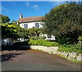
South View, Crossbush Lane, Crossbush, West Sussex
Image: © Jeff Gogarty
Taken: 20 Oct 2022
0.03 miles
5
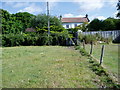
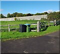
Gate to Crossbush Lane
Footpath 2202 leading from A27.
Image: © Peter Holmes
Taken: 17 Jul 2010
0.03 miles
6
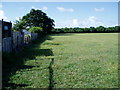
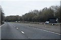
Footpath to A27
Footpath 2202 links Crossbush Lane with A27.
Image: © Peter Holmes
Taken: 17 Jul 2010
0.06 miles
7
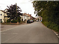
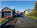
Crossbush Village
Crossbush Lane, running through the centre of the village/hamlet of Crossbush.
Image: © David Dixon
Taken: 7 Aug 2012
0.07 miles