IMAGES TAKEN NEAR TO
London Road, ARUNDEL, BN18 9LL
Introduction
This page details the photographs taken nearby to London Road, BN18 9LL by members of the Geograph project.
The Geograph project started in 2005 with the aim of publishing, organising and preserving representative images for every square kilometre of Great Britain, Ireland and the Isle of Man.

There are currently over 7.5m images from over14,400 individuals and you can help contribute to the project by visiting https://www.geograph.org.uk
Image Map
Images are licensed for reuse under creativecommons.org/licenses/by-sa/2.0
Notes
- Clicking on the map will re-center to the selected point.
- The higher the marker number, the further away the image location is from the centre of the postcode.
Image Listing (5 Images Found)
Images are licensed for reuse under creativecommons.org/licenses/by-sa/2.0
Image
Details
Distance
1
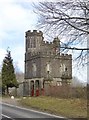
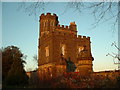
Duchess Lodge, Arundel Park
On the west side of Arundel park, along the London Road. As with much of Arundel Castle, this lodge is of 19th century origin - see http://www.britishlistedbuildings.co.uk/en-473068-duchess-lodge-and-attached-gate-piers-ho for listing text.
The gates are painted a deep crimson - the house-colour of the Arundel estate.
Image: © Stefan Czapski
Taken: 25 Feb 2012
0.00 miles
2
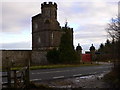
The Arundel Park lodge on the A284
Here it is viewed from the footpath to the west.
Image: © Shazz
Taken: 17 Jan 2011
0.03 miles
3
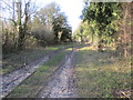
Track through Whiteways Plantation
Public footpath 2270 to Fairmile Bottom.
Image: © Peter Holmes
Taken: 21 Feb 2014
0.04 miles
4
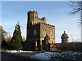
Duchess Lodge
On the A284 this is the western entrance to Arundel Park.
Image: © Dave Spicer
Taken: 26 Dec 2010
0.04 miles
5
Lodge at Arundel Park
At the West side of the park on the A284
Image: © Chris Shaw
Taken: 4 Dec 2005
0.06 miles