IMAGES TAKEN NEAR TO
London Road, ARUNDEL, BN18 9LJ
Introduction
This page details the photographs taken nearby to London Road, BN18 9LJ by members of the Geograph project.
The Geograph project started in 2005 with the aim of publishing, organising and preserving representative images for every square kilometre of Great Britain, Ireland and the Isle of Man.

There are currently over 7.5m images from over14,400 individuals and you can help contribute to the project by visiting https://www.geograph.org.uk
Image Map
Images are licensed for reuse under creativecommons.org/licenses/by-sa/2.0
Notes
- Clicking on the map will re-center to the selected point.
- The higher the marker number, the further away the image location is from the centre of the postcode.
Image Listing (9 Images Found)
Images are licensed for reuse under creativecommons.org/licenses/by-sa/2.0
Image
Details
Distance
1
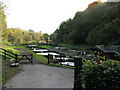
Watercress Beds
On the OS1:25000 map these are marked as Watercress beds, but now appear to be fish breeding pens for the lower ponds
Image: © Dave Spicer
Taken: 31 Oct 2008
0.14 miles
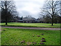
2
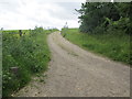
Track to Park Farm
Public footpath 346.
Image: © Peter Holmes
Taken: 15 Jun 2013
0.21 miles
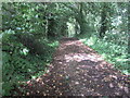
3
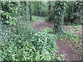
Path to Park Bottom
Public Footpath 3070.
Image: © Peter Holmes
Taken: 15 Jun 2013
0.22 miles
5
Bridleway and footpath junction south east of Park Farm
Image: © Shazz
Taken: 4 Jan 2013
0.22 miles
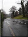
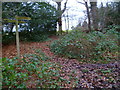
6
Track to Park Bottom Farm
Public footpath 3060.
Image: © Peter Holmes
Taken: 15 Jun 2013
0.23 miles

9
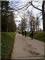
Riders on the Monarch's Way
Looking back along restricted byway 3062 towards Arundel Park.
Image: © Peter Holmes
Taken: 7 Mar 2009
0.25 miles