IMAGES TAKEN NEAR TO
Fitzalan Road, ARUNDEL, BN18 9JZ
Introduction
This page details the photographs taken nearby to Fitzalan Road, BN18 9JZ by members of the Geograph project.
The Geograph project started in 2005 with the aim of publishing, organising and preserving representative images for every square kilometre of Great Britain, Ireland and the Isle of Man.

There are currently over 7.5m images from over14,400 individuals and you can help contribute to the project by visiting https://www.geograph.org.uk
Image Map (Loading...)


Getting Data...Please wait
Leaflet Map data © OpenStreetMap
Images are licensed for reuse under creativecommons.org/licenses/by-sa/2.0
Notes
- Clicking on the map will re-center to the selected point.
- The higher the marker number, the further away the image location is from the centre of the postcode.
Image Listing (53 Images Found)
Images are licensed for reuse under creativecommons.org/licenses/by-sa/2.0
Image
Details
Distance
1
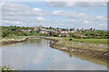
River Arun, Arundel
Approaching Arundel from the south with the Cathedral in front and Arundel Castle off to the right.
Image: © Chris Richardson
Taken: 3 May 2009
0.06 miles
2
Looking up the River Arun towards Arundel
The large building on the skyline is the cathedral in the next grid square to the north.
Image: © Shazz
Taken: 28 Nov 2015
0.07 miles
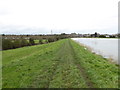
3
Arun journey
Some interest approaching Arundel. A former windmill on the right is now a private dwelling. It is the church rather than the castle that dominates this view of the town.
Next Image]
Image: © Graham Horn
Taken: 20 Apr 2008
0.08 miles
4
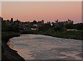
River Arun
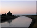
Viewed about five minutes after sunset with the sky pink over the town of Arundel and reflecting into the river. The A27 by-pass bridge is in the foreground with an old open deck bus crossing it. It had been parked in the car park of the Black Horse in Binsted where I'd tried to get a picture but the only view was looking straight at the sun so I gave up on the idea. Only noticed it crossing the bridge after downloading it onto my PC.
Image: © Simon Carey
Taken: 10 Oct 2010
0.08 miles
5
River Arun
Taken four minutes before sunrise near the former South Marsh Mill. A little mist is rising from the river but will clear in the next quarter of an hour.
Image: © Simon Carey
Taken: 24 Oct 2010
0.08 miles
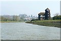
6
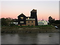
South Marsh Mill
A tower mill constructed in 1830 next to the river for ease of communication rather than drainage purposes. It operated by wind until a gale snapped its windshaft in 1915 and continued under mechanical power until its final closure in 1922. The mill was converted into a dwelling in the early 1940s when the last of its machinery was removed. Viewed a couple of minutes after sunset.
Image: © Simon Carey
Taken: 10 Oct 2010
0.08 miles
7
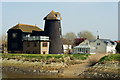
South Marsh Mill, Arundel, Sussex
Seen across the River Arun, at low tide. Formerly a windmill, this building has now been converted into a private residence.
http://en.wikipedia.org/wiki/South_Marsh_Mill,_Arundel
Image: © Peter Trimming
Taken: 29 Mar 2012
0.09 miles
8
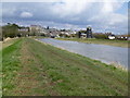
River Arun south of Arundel
South Marsh Mill is on the right, now a private house.
Image: © Dave Spicer
Taken: 19 Mar 2013
0.09 miles
9
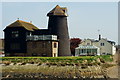
South Marsh Mill, Arundel, Sussex
Seen across the River Arun, at low tide. Formerly a windmill, this building has now been converted into a private residence.
http://en.wikipedia.org/wiki/South_Marsh_Mill,_Arundel
Image: © Peter Trimming
Taken: 29 Mar 2012
0.09 miles
10
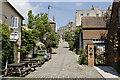
King's Arms Hill. Arundel
Looking north from Tarrant Street.
Image: © David Brogan
Taken: 23 May 2007
0.09 miles