IMAGES TAKEN NEAR TO
Houghton Bridge, ARUNDEL, BN18 9GY
Introduction
This page details the photographs taken nearby to Houghton Bridge, BN18 9GY by members of the Geograph project.
The Geograph project started in 2005 with the aim of publishing, organising and preserving representative images for every square kilometre of Great Britain, Ireland and the Isle of Man.

There are currently over 7.5m images from over14,400 individuals and you can help contribute to the project by visiting https://www.geograph.org.uk
Image Map
Images are licensed for reuse under creativecommons.org/licenses/by-sa/2.0
Notes
- Clicking on the map will re-center to the selected point.
- The higher the marker number, the further away the image location is from the centre of the postcode.
Image Listing (347 Images Found)
Images are licensed for reuse under creativecommons.org/licenses/by-sa/2.0
Image
Details
Distance
1
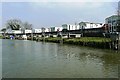
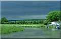
Arun journey
Caravan park at Houghton Bridge. Nice view from them to the river, but not so nice from the river looking up at them.
Next Image]
Image: © Graham Horn
Taken: 20 Apr 2008
0.00 miles
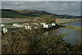
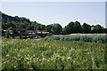
2
Riverside Park
Small caravan park built on the site of the wharf for the former chalk pits at Amberley where the ground has been raised to prevent flooding. Taken from the footpath that links the South Downs Way with the B2139.
Image: © Simon Carey
Taken: 24 Oct 2008
0.02 miles
3
Flooding in the Arun Valley
Just north of Amberley station. Most of the footpaths, on the raised river banks, appear still to be above water. An exception is the lower level path, to the right of picture.
Image: © Peter Trimming
Taken: 4 Feb 2014
0.02 miles
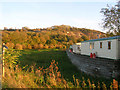
4
Residential caravans on the north side of Houghton Bridge
During flooding the caravans and nearby houses are protected by the high wall
Image: © Dave Spicer
Taken: 29 Mar 2009
0.02 miles
5
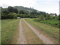
Track to Houghton Bridge
West Sussex Literary Trail on public footpath 3502/1.
Image: © Peter Holmes
Taken: 17 Aug 2013
0.03 miles
6
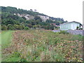
Footpath by Amberley Station
This path passes an extensive patch of spiky teazels, a plant formerly used for raising the nap on cloth. To the right is a trailer park by the banks of the Arun and in the distance is a chalk cliff which overlooks the river.
Image: © Colin Smith
Taken: 1 Sep 2007
0.03 miles
7
River Arun
Looking towards the bridge at Amberley.
Image: © Peter Trimming
Taken: 30 Jun 2018
0.03 miles
8
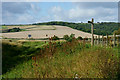
View Towards Bury Hill
Looking across the valley of the River Arun, which lies just beyond the sign. The South Downs Way can be seen, in the centre of picture, climbing up Bury Hill. I remember cycling up the hill, in the summer of 1994; luckily, the downland chalk was dry.
Image: © Peter Trimming
Taken: 13 Sep 2011
0.03 miles
10
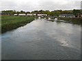
Looking north from Houghton Bridge
The boats are moored alongside a riverside cafe and a static caravan site
Image: © Dave Spicer
Taken: 24 Oct 2009
0.04 miles