IMAGES TAKEN NEAR TO
Park Place, ARUNDEL, BN18 9BE
Introduction
This page details the photographs taken nearby to Park Place, BN18 9BE by members of the Geograph project.
The Geograph project started in 2005 with the aim of publishing, organising and preserving representative images for every square kilometre of Great Britain, Ireland and the Isle of Man.

There are currently over 7.5m images from over14,400 individuals and you can help contribute to the project by visiting https://www.geograph.org.uk
Image Map
Images are licensed for reuse under creativecommons.org/licenses/by-sa/2.0
Notes
- Clicking on the map will re-center to the selected point.
- The higher the marker number, the further away the image location is from the centre of the postcode.
Image Listing (745 Images Found)
Images are licensed for reuse under creativecommons.org/licenses/by-sa/2.0
Image
Details
Distance
1
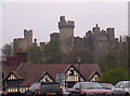
Arundel Castle
Taken from the bridge below at around 4pm
Image: © Alex Walton-Keeffe
Taken: 30 Apr 2006
0.02 miles
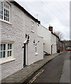
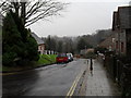
2
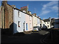
King Street
Connecting Maltravers Street with London Road. The street has been in existence since the mid 16th century though it has had a variety of names over the years. The cottages in view date from the 19th century.
Image: © Simon Carey
Taken: 13 Apr 2009
0.03 miles
3
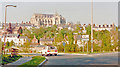
Arundel and its Cathedral, 1990
View NE from the A27 by-pass.
Image: © Ben Brooksbank
Taken: 30 Apr 1990
0.04 miles
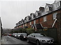
5
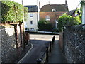
Junction of King Street with Maltravers Street
Image: © Nick Smith
Taken: 21 Oct 2008
0.05 miles
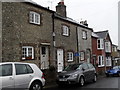
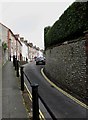
8
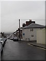
Approaching the junction of King Street and Bond Street
Image: © Basher Eyre
Taken: 30 Dec 2009
0.06 miles