IMAGES TAKEN NEAR TO
High Street, ARUNDEL, BN18 9AD
Introduction
This page details the photographs taken nearby to High Street, BN18 9AD by members of the Geograph project.
The Geograph project started in 2005 with the aim of publishing, organising and preserving representative images for every square kilometre of Great Britain, Ireland and the Isle of Man.

There are currently over 7.5m images from over14,400 individuals and you can help contribute to the project by visiting https://www.geograph.org.uk
Image Map
Images are licensed for reuse under creativecommons.org/licenses/by-sa/2.0
Notes
- Clicking on the map will re-center to the selected point.
- The higher the marker number, the further away the image location is from the centre of the postcode.
Image Listing (1126 Images Found)
Images are licensed for reuse under creativecommons.org/licenses/by-sa/2.0
Image
Details
Distance
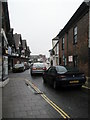
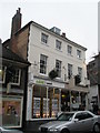
1

13 - 15 High St
Grade II listed. http://www.britishlistedbuildings.co.uk/en-297167-13-and-15-arundel
Image: © N Chadwick
Taken: 6 May 2012
0.00 miles
2
Arundel Bridge Antiques at the bottom of the High Street
Image: © Basher Eyre
Taken: 30 Dec 2009
0.00 miles
3
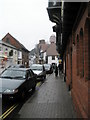
And still they came
As unpleasant a day you could wish for but the Arundel tourist business was still ticking over. Impressive!
Image: © Basher Eyre
Taken: 30 Dec 2009
0.00 miles
4
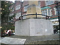
Such a small town, so many names
Inscriptions on the Arundel war memorial
Image: © Basher Eyre
Taken: 30 Dec 2009
0.00 miles
6
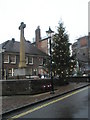
A wet day by the war memorial
Even the Christmas Tree looks fed up.
Image: © Basher Eyre
Taken: 30 Dec 2009
0.01 miles
8

17, High St
Grade II listed. http://www.britishlistedbuildings.co.uk/en-297168-17-arundel
Image: © N Chadwick
Taken: 6 May 2012
0.01 miles
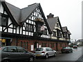
9
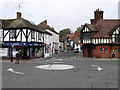
High Street
Taken from the western end of the bridge at the junction with Mill Road which was laid out in the 1890s to replace the older route to South Stoke that travelled through what is now the castle grounds. The post office on the corner was built at a similar style in a medieval style which had been encouraged by the Dukes of Norfolk from the mid 19th century onwards.
Image: © Simon Carey
Taken: 13 Apr 2009
0.01 miles