IMAGES TAKEN NEAR TO
Cob Lane, BN18 0YT
Introduction
This page details the photographs taken nearby to Cob Lane, BN18 0YT by members of the Geograph project.
The Geograph project started in 2005 with the aim of publishing, organising and preserving representative images for every square kilometre of Great Britain, Ireland and the Isle of Man.

There are currently over 7.5m images from over14,400 individuals and you can help contribute to the project by visiting https://www.geograph.org.uk
Image Map
Images are licensed for reuse under creativecommons.org/licenses/by-sa/2.0
Notes
- Clicking on the map will re-center to the selected point.
- The higher the marker number, the further away the image location is from the centre of the postcode.
Image Listing (6 Images Found)
Images are licensed for reuse under creativecommons.org/licenses/by-sa/2.0
Image
Details
Distance
1
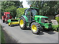
Tractor in Wandleys Lane
No room for other traffic.
Image: © Peter Holmes
Taken: 29 Jun 2013
0.21 miles
2
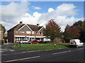
Orchard Crescent, Fontwell
A parade of shops built in 1938 to take advantage of the neighbouring A27. It once included a post office that has long gone and the four shops are now down to three and include an off licence, a saddlery and a shop seeming to specialise in items you can't find anywhere else.
Image: © Simon Carey
Taken: 30 Oct 2010
0.22 miles
3
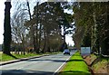
Looking south on Fontwell Avenue from the racecourse
Image: © Shazz
Taken: 21 Mar 2012
0.23 miles
4
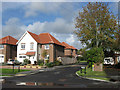
The Chase, Fontwell
Small cul-de-sac off Arundel Road built in the last few years as it does not appear on current aerial photographs.
Image: © Simon Carey
Taken: 30 Oct 2010
0.23 miles
5
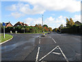
Arundel Road, Fontwell
Looking towards the junction with London Road formerly the A27 and A29 respectively superseded by the Fontwell By-Pass opened in 1988.
Image: © Simon Carey
Taken: 30 Oct 2010
0.24 miles
6
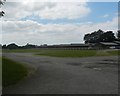
A scene of Fontwell Race Course
From the adjacent A29 road.
Image: © James Denham
Taken: 10 Jun 2015
0.24 miles