IMAGES TAKEN NEAR TO
Ford Road, ARUNDEL, BN18 0XL
Introduction
This page details the photographs taken nearby to Ford Road, BN18 0XL by members of the Geograph project.
The Geograph project started in 2005 with the aim of publishing, organising and preserving representative images for every square kilometre of Great Britain, Ireland and the Isle of Man.

There are currently over 7.5m images from over14,400 individuals and you can help contribute to the project by visiting https://www.geograph.org.uk
Image Map
Images are licensed for reuse under creativecommons.org/licenses/by-sa/2.0
Notes
- Clicking on the map will re-center to the selected point.
- The higher the marker number, the further away the image location is from the centre of the postcode.
Image Listing (19 Images Found)
Images are licensed for reuse under creativecommons.org/licenses/by-sa/2.0
Image
Details
Distance
1
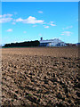
On the old airfield
RAF Ford is long closed, and is partly used for various industrial premises. Those beyond the barrier are reached from Ford Road on the other side of the airfield, the viewpoint being on an old runway where further premises are established, reached from Burndell Road.
Image: © Robin Webster
Taken: 26 Jan 2012
0.01 miles
2
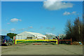
Tarmac Topblock Ltd
Part of the Tarmac company that manufactures concrete blocks located in a number of former large aircraft hangars on the former Ford Airfield. The hangars were first converted to industrial use in the early 1970s, Tarmac took over the site in 1984.
Image: © Simon Carey
Taken: 21 Mar 2008
0.04 miles
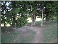
3
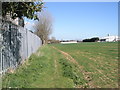
Footpath heading towards the Tarmac Depot
Image: © Basher Eyre
Taken: 8 Apr 2009
0.05 miles
4
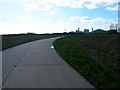
Tarmac Topblock Ltd
See Image for more information. The road is a former airfield service road now used as a driveway for Tarmac Topblock Ltd. It also forms the route of the footpath from Burndell to Ford. The factory and airfield in this section was built over the route of the former Portsmouth-Arundel Canal.
Image: © Simon Carey
Taken: 21 Mar 2008
0.08 miles
5

Air Raid Shelter near Ford Airfield
This is a disused air raid shelter, which would have been used during the Second World War by those working at the HMS Peregrine airfield at Ford. The airfield itself is now closed, with plans in place for its redevelopment.
Image: © Jim Butler
Taken: 28 Jul 2021
0.10 miles
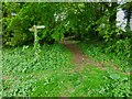
6
Footpath junction nearing the tarmac depot
Image: © Basher Eyre
Taken: 8 Apr 2009
0.10 miles
7
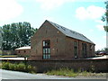
Ford Barn Conversion
Smart barn conversion near to east of grid square
Image: © Chris Shaw
Taken: Unknown
0.11 miles
9
Footpath to Wicks Farm
Public footpath 366 to Ford Lane.
Image: © Peter Holmes
Taken: 5 Jun 2010
0.13 miles
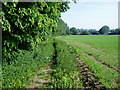
10
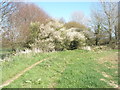
Signs of Spring on the footpath from Yapton to Ford
Image: © Basher Eyre
Taken: 8 Apr 2009
0.14 miles