IMAGES TAKEN NEAR TO
Courthill Farm Road, ARUNDEL, BN18 0RN
Introduction
This page details the photographs taken nearby to Courthill Farm Road, BN18 0RN by members of the Geograph project.
The Geograph project started in 2005 with the aim of publishing, organising and preserving representative images for every square kilometre of Great Britain, Ireland and the Isle of Man.

There are currently over 7.5m images from over14,400 individuals and you can help contribute to the project by visiting https://www.geograph.org.uk
Image Map
Images are licensed for reuse under creativecommons.org/licenses/by-sa/2.0
Notes
- Clicking on the map will re-center to the selected point.
- The higher the marker number, the further away the image location is from the centre of the postcode.
Image Listing (40 Images Found)
Images are licensed for reuse under creativecommons.org/licenses/by-sa/2.0
Image
Details
Distance
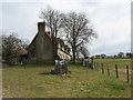
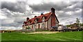
1
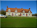
Gumber Farm Cottages
There is a National Trust bothy on this site but it is in a converted barn and not this building.
Image: © Shazz
Taken: 19 Jan 2014
0.00 miles
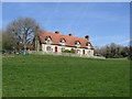
4
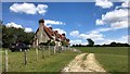
Cottages at Gumber Farm
According to the Explorer map, one of these is a Bothy
Image: © Dave Spicer
Taken: 13 Mar 2010
0.01 miles
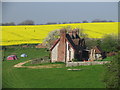
5
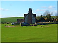
Gumber Farm
These buildings now used as a National Trust hostel
Image: © Peter Whitcomb
Taken: 6 Apr 2007
0.01 miles
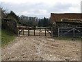
8
Gumber Farm - near Slindon, West Sussex
Image: © Ian Hawfinch
Taken: 19 Apr 2014
0.04 miles
9
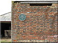
Commemorative plaque to Hilaire Belloc
A Sussex poet
Image: © Dave Spicer
Taken: 13 Mar 2010
0.05 miles