IMAGES TAKEN NEAR TO
Madehurst Road, ARUNDEL, BN18 0NJ
Introduction
This page details the photographs taken nearby to Madehurst Road, BN18 0NJ by members of the Geograph project.
The Geograph project started in 2005 with the aim of publishing, organising and preserving representative images for every square kilometre of Great Britain, Ireland and the Isle of Man.

There are currently over 7.5m images from over14,400 individuals and you can help contribute to the project by visiting https://www.geograph.org.uk
Image Map
Images are licensed for reuse under creativecommons.org/licenses/by-sa/2.0
Notes
- Clicking on the map will re-center to the selected point.
- The higher the marker number, the further away the image location is from the centre of the postcode.
Image Listing (60 Images Found)
Images are licensed for reuse under creativecommons.org/licenses/by-sa/2.0
Image
Details
Distance
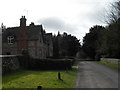
1
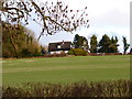
Madehurst Cottage seen from footpath to the west
Image: © Shazz
Taken: 16 Feb 2014
0.01 miles
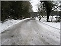
5
Looking down the lane to Punchbowl from St Mary Magdalene, Madehurst
Image: © Basher Eyre
Taken: 27 Feb 2010
0.10 miles
6
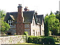
Madehurst
Old flint-walled cottages with diamond-patterned brickwork adjacent to the village church.
http://en.wikipedia.org/wiki/Madehurst
Image: © Colin Smith
Taken: 24 May 2009
0.10 miles
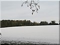
7
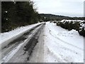
Road from Madehurst to the A29
Madehurst Wood is on the horizon
Image: © Dave Spicer
Taken: 10 Jan 2010
0.12 miles
8
St Mary Magdalene, Madehurst- churchyard (8)
Image: © Basher Eyre
Taken: 27 Feb 2010
0.12 miles
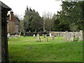
9
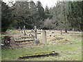
The cemetery opposite St Mary Magdalene, Madehurst
Image: © Basher Eyre
Taken: 27 Feb 2010
0.12 miles
10
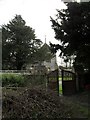
Looking from the cemetery gates across to St Mary Magdalene, Madehurst
Image: © Basher Eyre
Taken: 27 Feb 2010
0.12 miles