IMAGES TAKEN NEAR TO
Shellbridge Road, ARUNDEL, BN18 0NB
Introduction
This page details the photographs taken nearby to Shellbridge Road, BN18 0NB by members of the Geograph project.
The Geograph project started in 2005 with the aim of publishing, organising and preserving representative images for every square kilometre of Great Britain, Ireland and the Isle of Man.

There are currently over 7.5m images from over14,400 individuals and you can help contribute to the project by visiting https://www.geograph.org.uk
Image Map
Images are licensed for reuse under creativecommons.org/licenses/by-sa/2.0
Notes
- Clicking on the map will re-center to the selected point.
- The higher the marker number, the further away the image location is from the centre of the postcode.
Image Listing (6 Images Found)
Images are licensed for reuse under creativecommons.org/licenses/by-sa/2.0
Image
Details
Distance
1
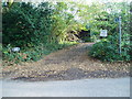
Start of bridleway 395
Route from Shellbridge Road (B2132) to Rewell Wood.
Image: © Peter Holmes
Taken: 6 Nov 2011
0.02 miles
2
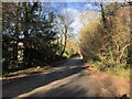
Shellbridge Road
Heading towards Slindon close to Bridle Cottage.
Image: © Chris Thomas-Atkin
Taken: 14 Jan 2019
0.06 miles
5
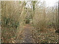
Danes Wood footpath
Slightly to the right are the first signs of Catkins
Image: © Dave Spicer
Taken: 31 Jan 2009
0.24 miles
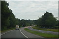
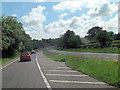
6
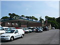
Second Hand Van Sales
This business known as Spur of Slindon sells vans and commercial vehicles from the site of an old petrol station on Fairmile Bottom, the A29 close to the junction with Shellbridge Road.
Image: © Nigel Mykura
Taken: 22 Jul 2013
0.25 miles