IMAGES TAKEN NEAR TO
Yapton Lane, ARUNDEL, BN18 0LS
Introduction
This page details the photographs taken nearby to Yapton Lane, BN18 0LS by members of the Geograph project.
The Geograph project started in 2005 with the aim of publishing, organising and preserving representative images for every square kilometre of Great Britain, Ireland and the Isle of Man.

There are currently over 7.5m images from over14,400 individuals and you can help contribute to the project by visiting https://www.geograph.org.uk
Image Map
Images are licensed for reuse under creativecommons.org/licenses/by-sa/2.0
Notes
- Clicking on the map will re-center to the selected point.
- The higher the marker number, the further away the image location is from the centre of the postcode.
Image Listing (16 Images Found)
Images are licensed for reuse under creativecommons.org/licenses/by-sa/2.0
Image
Details
Distance
1
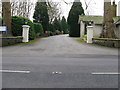
Entrance to Avisford Hotel and golf club
Image: © Dave Spicer
Taken: 31 Jan 2009
0.02 miles
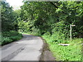
2
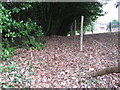
Covered footpath
Natural cover of Laurel for footpath
Image: © Dave Spicer
Taken: 31 Jan 2009
0.05 miles
3
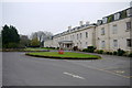
The Hilton Avisford Park
A very large hotel that was once a boarding school and presumably before that was a substantial residence.
Image: © Nigel Mykura
Taken: 12 Feb 2015
0.07 miles
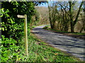
6
Footpath sign on Hedges Hill
This short stretch of road links Binsted to Walberton.
Image: © Dave Spicer
Taken: 29 Sep 2012
0.11 miles
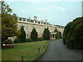
7
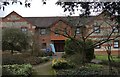
The Garden Lodge
The Garden Lodge Conference Centre at Avisford Park.
Image: © Chris Thomas-Atkin
Taken: 6 Mar 2018
0.12 miles
8
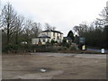
Oaks Restaurant
Marked on OS maps as a Public House, now a restaurant
Image: © Dave Spicer
Taken: 31 Jan 2009
0.16 miles
9
All the World
The name of this small triangle of land according to the 1838 tithe map that is bounded by Hedges Hill, Binsted Lane and a public footpath. Now a garden belonging to a house called Ashurst which is just visible to the left. A small pocket of Reading Beds clay meant this was the site of kilns for the production of pottery by the 14th and 15th century. A kiln still existed in the 17th century though the site was more a clay pit the digging of which has accentuated the slope. By this date it was known as All the World, as was a house that existed on the site which had been demolished by 1716. The name stuck and was still used in the tithe map though by that time it was a copse which it remained until recently where it seems to have been grubbed to make the current garden. The current houses at the top of the hill were constructed during the interwar period.
Image: © Simon Carey
Taken: 24 Oct 2010
0.17 miles
10
Andrew's Field
The name of the field according to the 1838 tithe map viewed from the car park of the Black Horse. Part of the field is now greens for Avisford Park golf course.
Image: © Simon Carey
Taken: 10 Oct 2010
0.18 miles