IMAGES TAKEN NEAR TO
Binsted, ARUNDEL, BN18 0LQ
Introduction
This page details the photographs taken nearby to BN18 0LQ by members of the Geograph project.
The Geograph project started in 2005 with the aim of publishing, organising and preserving representative images for every square kilometre of Great Britain, Ireland and the Isle of Man.

There are currently over 7.5m images from over14,400 individuals and you can help contribute to the project by visiting https://www.geograph.org.uk
Image Map
Images are licensed for reuse under creativecommons.org/licenses/by-sa/2.0
Notes
- Clicking on the map will re-center to the selected point.
- The higher the marker number, the further away the image location is from the centre of the postcode.
Image Listing (6 Images Found)
Images are licensed for reuse under creativecommons.org/licenses/by-sa/2.0
Image
Details
Distance
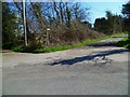
1
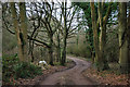
Binsted Lane at the National Park boundary
The stream crossed at the bottom of the dip forms the South Downs National Park boundary here. This is a section of Binsted Lane lacking tarmac, but a better surface than further back, which has a few moderate potholes.
Image: © Robin Webster
Taken: 29 Jan 2012
0.08 miles
2
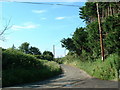
Goose Green
Country Lane near the SW of this square
Image: © Chris Shaw
Taken: Unknown
0.16 miles
3
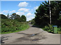
Binsted Lane heading north
After travelling south from the A27 the lane returns to the A road, albeit in name only as one section is reduced a track.
Image: © Dave Spicer
Taken: 29 Sep 2012
0.17 miles
4
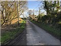
Approaching Slate Barn Farm
On Binsted Lane nearing the farm on the corner of the lane.
Image: © Chris Thomas-Atkin
Taken: 14 Jan 2019
0.22 miles
6
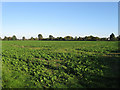
Parish Piece
The name of the field according to the 1838 tithe map that has been extended to include New Barn Field to the east.
Image: © Simon Carey
Taken: 10 Oct 2010
0.23 miles