IMAGES TAKEN NEAR TO
Cherry Avenue, ARUNDEL, BN18 0LB
Introduction
This page details the photographs taken nearby to Cherry Avenue, BN18 0LB by members of the Geograph project.
The Geograph project started in 2005 with the aim of publishing, organising and preserving representative images for every square kilometre of Great Britain, Ireland and the Isle of Man.

There are currently over 7.5m images from over14,400 individuals and you can help contribute to the project by visiting https://www.geograph.org.uk
Image Map
Images are licensed for reuse under creativecommons.org/licenses/by-sa/2.0
Notes
- Clicking on the map will re-center to the selected point.
- The higher the marker number, the further away the image location is from the centre of the postcode.
Image Listing (7 Images Found)
Images are licensed for reuse under creativecommons.org/licenses/by-sa/2.0
Image
Details
Distance
1
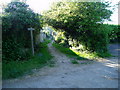
Public footpath 166
From Bilsham Road to Grevatt's Lane.
Image: © Peter Holmes
Taken: 22 May 2010
0.09 miles
3
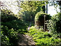
Junction on public footpath 166
Footpath 167 to Burndell Road branches off to the left.
Image: © Peter Holmes
Taken: 22 May 2010
0.13 miles
4
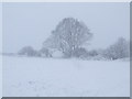
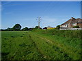
Mature oak next to Yapton allotments
This is one of the fine mature oaks within the parish of Yapton and one of few within this square. The view is taken in winter facing south and from the footpath that leads to and beyond this tree. It is situated beside the footpath that flanks the eastern side of the allotments and ultimately runs down to the sea between Clymping and Middleton
Image: © Peter H Jones
Taken: 2 Jan 2010
0.16 miles
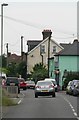
5
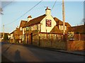
The Lamb, Yapton
Next to the B2132 Middleton-on-sea to Yapton road.
Image: © Janine Forbes
Taken: 5 Feb 2006
0.18 miles
6
Public footpath 167
Showing rear of houses in Park Drive.
Image: © Peter Holmes
Taken: 22 May 2010
0.19 miles
7
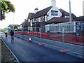
The Lamb Inn, Bilsham Road
Pub sign has been changed since the previous picture Image
Image: © Peter Holmes
Taken: 22 May 2010
0.19 miles