IMAGES TAKEN NEAR TO
Ford Road, ARUNDEL, BN18 0FP
Introduction
This page details the photographs taken nearby to Ford Road, BN18 0FP by members of the Geograph project.
The Geograph project started in 2005 with the aim of publishing, organising and preserving representative images for every square kilometre of Great Britain, Ireland and the Isle of Man.

There are currently over 7.5m images from over14,400 individuals and you can help contribute to the project by visiting https://www.geograph.org.uk
Image Map
Images are licensed for reuse under creativecommons.org/licenses/by-sa/2.0
Notes
- Clicking on the map will re-center to the selected point.
- The higher the marker number, the further away the image location is from the centre of the postcode.
Image Listing (18 Images Found)
Images are licensed for reuse under creativecommons.org/licenses/by-sa/2.0
Image
Details
Distance
1
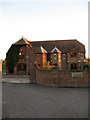
The Priory
Modern house built on the site of Tortington Priory, an Augustinian house that existed between the 12th century and dissolution in 1536. The site became Priory Farm which incorporated the remnants of the priory in the farm buildings until that too was sold up and its outhouses converted or rebuilt.
Image: © Simon Carey
Taken: 10 Oct 2010
0.08 miles
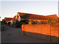
2
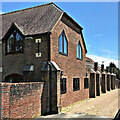
Priory Manor
The larger building of several here at the site of Tortington Priory.
Image: © Robin Webster
Taken: 20 Jun 2010
0.08 miles
3
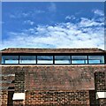
Priory Manor - roof feature
See Image Before reading Simon's description I wasn't sure whether this was a house or a religious building. It looks like the latter at the front. It straddles two grid squares: TQ0005 and TQ0006.
Image: © Ian Hawfinch
Taken: 6 Jun 2021
0.08 miles
4
Brooklands
Converted barns and stables on the site of Priory Farm which itself was constructed on the site of Tortington Priory which existed from the 12th century until dissolution in 1536.
Image: © Simon Carey
Taken: 10 Oct 2010
0.09 miles
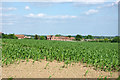
5
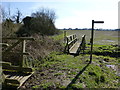
Footbridge across drainage channel
See http://www.geograph.org.uk/photo/3377178 for a view the other way.
Image: © Shazz
Taken: 28 Nov 2015
0.09 miles
6
Priory Manor - side view
See Image Before reading Simon's description I wasn't sure whether this was a house or a religious building. It looks like the latter at the front. It straddles two grid squares: TQ0005 and TQ0006.
Image: © Ian Hawfinch
Taken: 6 Jun 2021
0.09 miles
8
The Twenty Acres
The name of the field according to the 1840 tithe map that has been extended to include Image to the north. Hanger Down House is to the right.
Image: © Simon Carey
Taken: 10 Oct 2010
0.10 miles

10
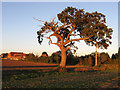
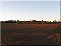
Golden Oak near Priory Farm
Bathed in the sunshine of the setting sun. Beyond are two footbridges carrying the footpath from Tortington Manor behind the hedgerow and into waist high nettles. The Priory is the building to the left.
Image: © Simon Carey
Taken: 10 Oct 2010
0.12 miles