IMAGES TAKEN NEAR TO
Main Road, ARUNDEL, BN18 0ET
Introduction
This page details the photographs taken nearby to Main Road, BN18 0ET by members of the Geograph project.
The Geograph project started in 2005 with the aim of publishing, organising and preserving representative images for every square kilometre of Great Britain, Ireland and the Isle of Man.

There are currently over 7.5m images from over14,400 individuals and you can help contribute to the project by visiting https://www.geograph.org.uk
Image Map
Images are licensed for reuse under creativecommons.org/licenses/by-sa/2.0
Notes
- Clicking on the map will re-center to the selected point.
- The higher the marker number, the further away the image location is from the centre of the postcode.
Image Listing (66 Images Found)
Images are licensed for reuse under creativecommons.org/licenses/by-sa/2.0
Image
Details
Distance
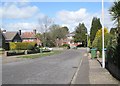
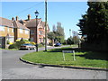
2
Looking into Briar Close
Other parts of Briar Close are seen at http://www.geograph.org.uk/photo/1243266 and http://www.geograph.org.uk/photo/1243268.
Image: © Shazz
Taken: 2 May 2014
0.03 miles
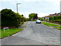
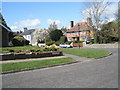
5
Approaching the junction of Briar Close and Church Lane
Image: © Basher Eyre
Taken: 8 Apr 2009
0.04 miles
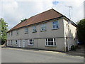
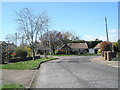
6
Looking from Briar Close into Church Lane
Image: © Basher Eyre
Taken: 8 Apr 2009
0.04 miles
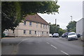
8
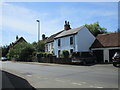
Cottages on the south side of Main Road, Yapton
Image: © Jonathan Thacker
Taken: 15 Jun 2016
0.04 miles
9
Looking from Briar Close towards Yapton Recreation Ground
Image: © Basher Eyre
Taken: 8 Apr 2009
0.04 miles
10
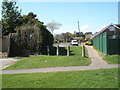
Looking from Yapton Recreation Ground into Briar Close
Image: © Basher Eyre
Taken: 8 Apr 2009
0.04 miles