IMAGES TAKEN NEAR TO
The Poplars, ARUNDEL, BN18 0EQ
Introduction
This page details the photographs taken nearby to The Poplars, BN18 0EQ by members of the Geograph project.
The Geograph project started in 2005 with the aim of publishing, organising and preserving representative images for every square kilometre of Great Britain, Ireland and the Isle of Man.

There are currently over 7.5m images from over14,400 individuals and you can help contribute to the project by visiting https://www.geograph.org.uk
Image Map (Loading...)


Getting Data...Please wait
Leaflet Map data © OpenStreetMap
Images are licensed for reuse under creativecommons.org/licenses/by-sa/2.0
Notes
- Clicking on the map will re-center to the selected point.
- The higher the marker number, the further away the image location is from the centre of the postcode.
Image Listing (102 Images Found)
Images are licensed for reuse under creativecommons.org/licenses/by-sa/2.0
Image
Details
Distance
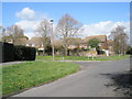
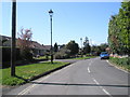
6
Looking from St Mary's Churchyard into Church Lane
Image: © Basher Eyre
Taken: 8 Apr 2009
0.07 miles
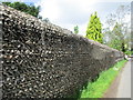
8
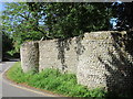
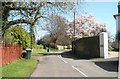
Flint wall on the bend in Church Lane
Was there once an entrance here?
Image: © Jonathan Thacker
Taken: 15 Jun 2016
0.07 miles
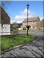
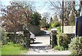
9
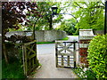
Looking past the church gates into Church Lane
Image: © Shazz
Taken: 2 May 2014
0.07 miles