IMAGES TAKEN NEAR TO
Church Road, ARUNDEL, BN18 0EP
Introduction
This page details the photographs taken nearby to Church Road, BN18 0EP by members of the Geograph project.
The Geograph project started in 2005 with the aim of publishing, organising and preserving representative images for every square kilometre of Great Britain, Ireland and the Isle of Man.

There are currently over 7.5m images from over14,400 individuals and you can help contribute to the project by visiting https://www.geograph.org.uk
Image Map
Images are licensed for reuse under creativecommons.org/licenses/by-sa/2.0
Notes
- Clicking on the map will re-center to the selected point.
- The higher the marker number, the further away the image location is from the centre of the postcode.
Image Listing (87 Images Found)
Images are licensed for reuse under creativecommons.org/licenses/by-sa/2.0
Image
Details
Distance
1
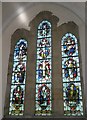
Stained glass window within St Mary's, Yapton
Image: © Basher Eyre
Taken: 8 Apr 2009
0.04 miles
2

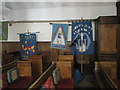
1939-1945 war memorial within St Mary's, Yapton
Image: © Basher Eyre
Taken: 8 Apr 2009
0.05 miles
3

Old Yews in an overgrown churchyard, Yapton, parish church
Image: © Derek Voller
Taken: 12 Sep 2014
0.05 miles
4
Looking from Church Lane towards St Mary's Yapton
Image: © Basher Eyre
Taken: 8 Apr 2009
0.05 miles

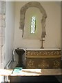
10

Memorial bird fountain in the churchyard at St Mary's Yapton
Image: © Basher Eyre
Taken: 8 Apr 2009
0.06 miles