IMAGES TAKEN NEAR TO
Ford Lane, ARUNDEL, BN18 0EF
Introduction
This page details the photographs taken nearby to Ford Lane, BN18 0EF by members of the Geograph project.
The Geograph project started in 2005 with the aim of publishing, organising and preserving representative images for every square kilometre of Great Britain, Ireland and the Isle of Man.

There are currently over 7.5m images from over14,400 individuals and you can help contribute to the project by visiting https://www.geograph.org.uk
Image Map
Images are licensed for reuse under creativecommons.org/licenses/by-sa/2.0
Notes
- Clicking on the map will re-center to the selected point.
- The higher the marker number, the further away the image location is from the centre of the postcode.
Image Listing (142 Images Found)
Images are licensed for reuse under creativecommons.org/licenses/by-sa/2.0
Image
Details
Distance
1
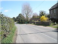
Looking eastwards along Ford Lane towards the Victorian Business Centre
Image: © Basher Eyre
Taken: 8 Apr 2009
0.00 miles
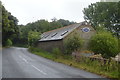
6
Looking westwards along Ford Lane towards the Victorian Business Centre
Image: © Basher Eyre
Taken: 8 Apr 2009
0.02 miles

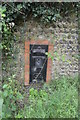
10
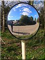
Mirror Mirror
Located on a bend in the service road to the Tarmac factory near the concealed entrance to the Mill Studio. The houses beyond the road in the mirror are part of Rodney Crescent erected after the war for Naval personnel working on the nearby airfield. There's also some strange bloke with a camera.
Image: © Simon Carey
Taken: 21 Mar 2008
0.04 miles