IMAGES TAKEN NEAR TO
Drove Lane, Main Road, ARUNDEL, BN18 0EB
Introduction
This page details the photographs taken nearby to Drove Lane, Main Road, BN18 0EB by members of the Geograph project.
The Geograph project started in 2005 with the aim of publishing, organising and preserving representative images for every square kilometre of Great Britain, Ireland and the Isle of Man.

There are currently over 7.5m images from over14,400 individuals and you can help contribute to the project by visiting https://www.geograph.org.uk
Image Map
Images are licensed for reuse under creativecommons.org/licenses/by-sa/2.0
Notes
- Clicking on the map will re-center to the selected point.
- The higher the marker number, the further away the image location is from the centre of the postcode.
Image Listing (4 Images Found)
Images are licensed for reuse under creativecommons.org/licenses/by-sa/2.0
Image
Details
Distance
1

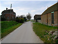
Drove Lane
Public footpath 155 on track to Drove Lane Farm.
Image: © Peter Holmes
Taken: 21 Aug 2010
0.06 miles
2
Drove Lane Farm
Drove Lane was mentioned as early as 1542 which suggests the lane came first then the farm after. This looks south west through the farm from the north eastern edge of the square.
Image: © Simon Carey
Taken: 18 Mar 2006
0.06 miles
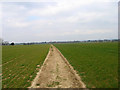
3

Route to Bilsham
Footpath 148 from Drove Lane.
Image: © Peter Holmes
Taken: 21 Aug 2010
0.12 miles
4
Footpath, near Yapton
Looking north west towards Drove Lane.
Image: © Simon Carey
Taken: 18 Mar 2006
0.21 miles