IMAGES TAKEN NEAR TO
East Bank, North End Road, ARUNDEL, BN18 0DJ
Introduction
This page details the photographs taken nearby to East Bank, North End Road, BN18 0DJ by members of the Geograph project.
The Geograph project started in 2005 with the aim of publishing, organising and preserving representative images for every square kilometre of Great Britain, Ireland and the Isle of Man.

There are currently over 7.5m images from over14,400 individuals and you can help contribute to the project by visiting https://www.geograph.org.uk
Image Map
Images are licensed for reuse under creativecommons.org/licenses/by-sa/2.0
Notes
- Clicking on the map will re-center to the selected point.
- The higher the marker number, the further away the image location is from the centre of the postcode.
Image Listing (19 Images Found)
Images are licensed for reuse under creativecommons.org/licenses/by-sa/2.0
Image
Details
Distance
2
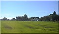
Footpath to Yapton church off Ford lane
Image: © Dave Spicer
Taken: 20 Aug 2012
0.12 miles
3
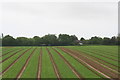
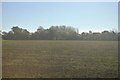
Railway view
Looking south from the train across a field, towards Ford Lane near North End.
Image: © Chris
Taken: 14 Jun 2013
0.13 miles
4
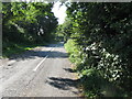
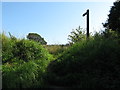
Maypole Lane heading for the Maypole inn
Image: © Dave Spicer
Taken: 20 Aug 2012
0.13 miles
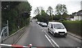
8
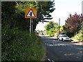
Level crossing on North End Road Barnham
Image: © Dave Spicer
Taken: 20 Aug 2012
0.16 miles
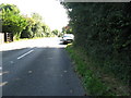
9
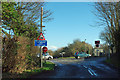
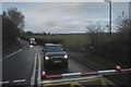
Lake Lane joins the B2132
Just round the corner is a level crossing, one of many on this stretch of railway. The level crossing lights are duplicated, one set aimed for the B2132 and the other aimed down Lake lane.
Image: © Robin Webster
Taken: 26 Jan 2012
0.17 miles