IMAGES TAKEN NEAR TO
North End Road, ARUNDEL, BN18 0DH
Introduction
This page details the photographs taken nearby to North End Road, BN18 0DH by members of the Geograph project.
The Geograph project started in 2005 with the aim of publishing, organising and preserving representative images for every square kilometre of Great Britain, Ireland and the Isle of Man.

There are currently over 7.5m images from over14,400 individuals and you can help contribute to the project by visiting https://www.geograph.org.uk
Image Map (Loading...)


Getting Data...Please wait
Leaflet Map data © OpenStreetMap
Images are licensed for reuse under creativecommons.org/licenses/by-sa/2.0
Notes
- Clicking on the map will re-center to the selected point.
- The higher the marker number, the further away the image location is from the centre of the postcode.
Image Listing (18 Images Found)
Images are licensed for reuse under creativecommons.org/licenses/by-sa/2.0
Image
Details
Distance

2
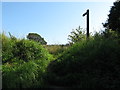
Footpath to Yapton church off Ford lane
Image: © Dave Spicer
Taken: 20 Aug 2012
0.09 miles
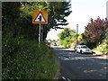
3
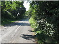
Maypole Lane heading for the Maypole inn
Image: © Dave Spicer
Taken: 20 Aug 2012
0.11 miles
5
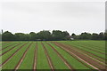
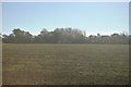
Railway view
Looking south from the train across a field, towards Ford Lane near North End.
Image: © Chris
Taken: 14 Jun 2013
0.14 miles
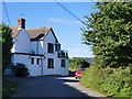
8
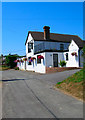
Maypole Inn, Maypole Lane
Now a dead end, Maypole Lane was cut off by the railway. The lane now consists of an inn and a caravan park with the remainder being used as a driveway to the converted Lake Barn.
Image: © Simon Carey
Taken: 2 Jul 2006
0.18 miles
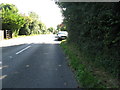
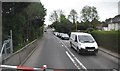
9
Level crossing on North End Road Barnham
Image: © Dave Spicer
Taken: 20 Aug 2012
0.18 miles
10
The Maypole Inn, Yapton
Rather tucked away, to the north of the village centre.
Image: © Stefan Czapski
Taken: 7 Sep 2016
0.19 miles