IMAGES TAKEN NEAR TO
Wood Pigeon Close, BN18 0BE
Introduction
This page details the photographs taken nearby to Wood Pigeon Close, BN18 0BE by members of the Geograph project.
The Geograph project started in 2005 with the aim of publishing, organising and preserving representative images for every square kilometre of Great Britain, Ireland and the Isle of Man.

There are currently over 7.5m images from over14,400 individuals and you can help contribute to the project by visiting https://www.geograph.org.uk
Image Map
Images are licensed for reuse under creativecommons.org/licenses/by-sa/2.0
Notes
- Clicking on the map will re-center to the selected point.
- The higher the marker number, the further away the image location is from the centre of the postcode.
Image Listing (9 Images Found)
Images are licensed for reuse under creativecommons.org/licenses/by-sa/2.0
Image
Details
Distance
1
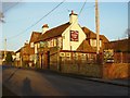
The Lamb, Yapton
Next to the B2132 Middleton-on-sea to Yapton road.
Image: © Janine Forbes
Taken: 5 Feb 2006
0.07 miles
2
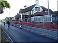
The Lamb Inn, Bilsham Road
Pub sign has been changed since the previous picture Image
Image: © Peter Holmes
Taken: 22 May 2010
0.08 miles
3
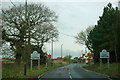
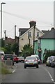
Bilsham Road enters Yapton
Up ahead on the right is the Lamb Inn.
Image: © Robin Webster
Taken: 29 Jan 2012
0.14 miles
4
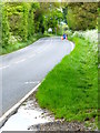
The way to Yapton from the south
This was taken from the footpath junction.
Image: © Shazz
Taken: 2 May 2014
0.18 miles
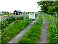
6

Old railway covered van
Adjacent to footpath 144 and used for fodder storage and shelter.
Image: © Peter Holmes
Taken: 21 Aug 2010
0.24 miles
7
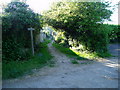
Public footpath 166
From Bilsham Road to Grevatt's Lane.
Image: © Peter Holmes
Taken: 22 May 2010
0.24 miles
8
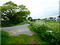
Footpath by allotments by Bilsham Road
The rust coloured van on the right of the path is seen from 2010 at http://www.geograph.org.uk/photo/2026244 when it seems there were no allotments.
Image: © Shazz
Taken: 2 May 2014
0.25 miles