IMAGES TAKEN NEAR TO
Yapton Lane, ARUNDEL, BN18 0AN
Introduction
This page details the photographs taken nearby to Yapton Lane, BN18 0AN by members of the Geograph project.
The Geograph project started in 2005 with the aim of publishing, organising and preserving representative images for every square kilometre of Great Britain, Ireland and the Isle of Man.

There are currently over 7.5m images from over14,400 individuals and you can help contribute to the project by visiting https://www.geograph.org.uk
Image Map
Images are licensed for reuse under creativecommons.org/licenses/by-sa/2.0
Notes
- Clicking on the map will re-center to the selected point.
- The higher the marker number, the further away the image location is from the centre of the postcode.
Image Listing (15 Images Found)
Images are licensed for reuse under creativecommons.org/licenses/by-sa/2.0
Image
Details
Distance
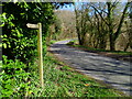
1
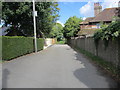
Avisford Park Road (3)
Public footpath 333 to Yapton Lane.
Image: © Peter Holmes
Taken: 7 Sep 2013
0.05 miles
2

Lost Love, by Bob Fuller (detail).
There were several sculptures by Bob Fuller, displayed behind the first tee of the Hilton Hotel golf course. I liked this weeping lady, but couldn't afford her.
Image: © Mike White
Taken: 23 Aug 2010
0.11 miles
3
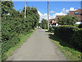
Avisford Park Road (2)
Public footpath 333 to Yapton Lane.
Image: © Peter Holmes
Taken: 7 Sep 2013
0.11 miles
4
Avisford Park Road (1)
Public footpath 333 to Yapton Lane.
Image: © Peter Holmes
Taken: 7 Sep 2013
0.15 miles
5

The first tee, Hilton Hotel Golf Course
The hotel golf course is an excellent amenity for non-golfers as well as fanatics.
Image: © Mike White
Taken: 23 Aug 2010
0.16 miles
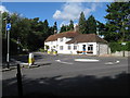
6
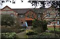
The Garden Lodge
The Garden Lodge Conference Centre at Avisford Park.
Image: © Chris Thomas-Atkin
Taken: 6 Mar 2018
0.17 miles
7
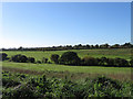
Avisford Park Golf Course
Viewed from the car park of the Black Lion public house. The greens line the small valley containing Binsted Brook, whilst that in the foreground was once a field called Simmerlee Field according to the 1838 tithe map.
Image: © Simon Carey
Taken: 24 Oct 2010
0.19 miles
8
Forge Gallery at Blacksmith's Corner Walberton
Image: © Dave Spicer
Taken: 29 Sep 2012
0.22 miles
10
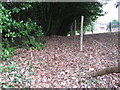
Covered footpath
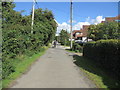
Natural cover of Laurel for footpath
Image: © Dave Spicer
Taken: 31 Jan 2009
0.23 miles