IMAGES TAKEN NEAR TO
Roedale Road, BRIGHTON, BN1 7GX
Introduction
This page details the photographs taken nearby to Roedale Road, BN1 7GX by members of the Geograph project.
The Geograph project started in 2005 with the aim of publishing, organising and preserving representative images for every square kilometre of Great Britain, Ireland and the Isle of Man.

There are currently over 7.5m images from over14,400 individuals and you can help contribute to the project by visiting https://www.geograph.org.uk
Image Map
Images are licensed for reuse under creativecommons.org/licenses/by-sa/2.0
Notes
- Clicking on the map will re-center to the selected point.
- The higher the marker number, the further away the image location is from the centre of the postcode.
Image Listing (97 Images Found)
Images are licensed for reuse under creativecommons.org/licenses/by-sa/2.0
Image
Details
Distance
1
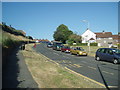
Davey Drive
viewed from the Upper Hollingdean Road
Image: © Paul Gillett
Taken: 27 Jun 2009
0.01 miles
2
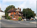
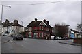
The Hollingbury, Roedale Road, Hollingdean, Brighton
A public house located at the junction with Upper Hollingdean Road that was built in the early 1900s. Very much a locals pub
Image: © Simon Carey
Taken: 4 Oct 2015
0.03 miles
3
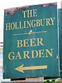
Sign for The Hollingbury, Upper Hollingdean Road / Roedale Road, BN1
See Image
Image: © Mike Quinn
Taken: 25 Jun 2014
0.03 miles
4
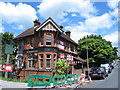
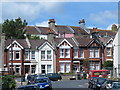
The Hollingbury, Upper Hollingdean Road / Roedale Road, BN1
Image: © Mike Quinn
Taken: 25 Jun 2014
0.03 miles
5
The Hollingbury Pub
The Hollingbury is on Upper Holligndean Rd at its junction with Roedale Rd which is the road to the right of the pub.
Image: © Nigel Mykura
Taken: 13 Feb 2011
0.03 miles

9

Frydays Fish Bar, Upper Hollingdean Road, BN1
Image: © Mike Quinn
Taken: 25 Jun 2014
0.04 miles
10

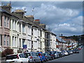
Upper Hollingdean Road, Hollingdean, Brighton
Built in the late 1890s to replace the former route of Hollingdean Road which ran straight through what is now a local council depot. The new road forms an arc between the immediate west of the railway bridge and Ditchling Road.
Image: © Simon Carey
Taken: 4 Oct 2015
0.05 miles