IMAGES TAKEN NEAR TO
Hollingdean Lane, BRIGHTON, BN1 7BB
Introduction
This page details the photographs taken nearby to Hollingdean Lane, BN1 7BB by members of the Geograph project.
The Geograph project started in 2005 with the aim of publishing, organising and preserving representative images for every square kilometre of Great Britain, Ireland and the Isle of Man.

There are currently over 7.5m images from over14,400 individuals and you can help contribute to the project by visiting https://www.geograph.org.uk
Image Map
Images are licensed for reuse under creativecommons.org/licenses/by-sa/2.0
Notes
- Clicking on the map will re-center to the selected point.
- The higher the marker number, the further away the image location is from the centre of the postcode.
Image Listing (166 Images Found)
Images are licensed for reuse under creativecommons.org/licenses/by-sa/2.0
Image
Details
Distance
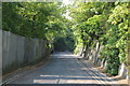
1
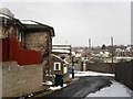
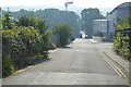
The Old Cottage, Hollingdean Lane
Built in the 19th century and originally fronted onto what was Dog Kennel Road then Hollingdean Road before that road was rerouted in the late 19th century as Upper Hollingdean Road. Hollingdean Lane, as the western part of the old road had become, was also rerouted turning to the south before continuing its westward journey to Ditchling Road. Beyond the fence is a council depot which has been operating from the site since the late 19th century too.
Image: © Simon Carey
Taken: 12 Mar 2013
0.00 miles
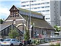
3
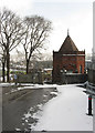
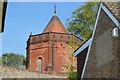
Mortuary Chapel, Florence Place
The octagonal, turreted chapel serves a small Jewish cemetery that was first used in 1826. The chapel was added later towards the end of the 19th century and is built along the line of the old course of Hollingdean Road.
Image: © Simon Carey
Taken: 12 Mar 2013
0.02 miles
4
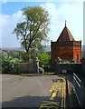
Mortuary Chapel, Florence Place, Brighton
The octagonal, turreted chapel serves a small Jewish cemetery that was first used in 1826. The chapel was added later towards the end of the 19th century and is built along the line of the old course of Hollingdean Road. See Image for a view in the snow taken a few years ago where in the intervening years a couple of the trees to the left have been lost allowing a view of Davey Drive in the distance.
Image: © Simon Carey
Taken: 4 Oct 2015
0.02 miles
7
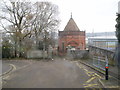
Chapel at the Jewish Cemetery, Florence Place
An octagonal brick and terracotta chapel built in 1893 by Thomas Lainson to serve the small cemetery, established by Brighton's Jewish community in 1826. Listed at Grade II by English Heritage.
Image: © Peter Holmes
Taken: 12 Dec 2010
0.03 miles
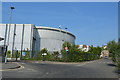
8
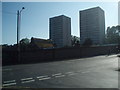
Hollingdean's twin towers
Controversial towers which dominate the Brighton skyline
Image: © Paul Gillett
Taken: 27 Jun 2009
0.05 miles
10
Industrial building, Hollingdean Recycling Depot
Image: © Mike Quinn
Taken: 25 Jun 2014
0.06 miles