IMAGES TAKEN NEAR TO
Challen Vale, LITTLEHAMPTON, BN17 7BZ
Introduction
This page details the photographs taken nearby to Challen Vale, BN17 7BZ by members of the Geograph project.
The Geograph project started in 2005 with the aim of publishing, organising and preserving representative images for every square kilometre of Great Britain, Ireland and the Isle of Man.

There are currently over 7.5m images from over14,400 individuals and you can help contribute to the project by visiting https://www.geograph.org.uk
Image Map
Images are licensed for reuse under creativecommons.org/licenses/by-sa/2.0
Notes
- Clicking on the map will re-center to the selected point.
- The higher the marker number, the further away the image location is from the centre of the postcode.
Image Listing (10 Images Found)
Images are licensed for reuse under creativecommons.org/licenses/by-sa/2.0
Image
Details
Distance
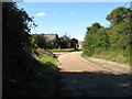
1
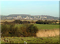
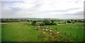
View from the railway towards Arundel
This picture is close to Arundel Junction where two railway lines meet.
Image: © Nigel Freeman
Taken: Unknown
0.07 miles
5
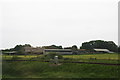
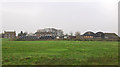
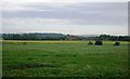
Brook Barn Farm
From the train at Arundel Junction. The line across the bottom of the photo goes to the east.
Image: © Chris
Taken: 14 Jun 2013
0.16 miles
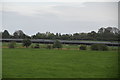
10
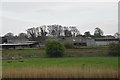
View north from the West Coastway Line
In the distance is St Mary's Church, Lyminster (in a different square).
Image: © N Chadwick
Taken: 8 May 2011
0.25 miles