IMAGES TAKEN NEAR TO
East Ham Road, LITTLEHAMPTON, BN17 7AW
Introduction
This page details the photographs taken nearby to East Ham Road, BN17 7AW by members of the Geograph project.
The Geograph project started in 2005 with the aim of publishing, organising and preserving representative images for every square kilometre of Great Britain, Ireland and the Isle of Man.

There are currently over 7.5m images from over14,400 individuals and you can help contribute to the project by visiting https://www.geograph.org.uk
Image Map
Images are licensed for reuse under creativecommons.org/licenses/by-sa/2.0
Notes
- Clicking on the map will re-center to the selected point.
- The higher the marker number, the further away the image location is from the centre of the postcode.
Image Listing (239 Images Found)
Images are licensed for reuse under creativecommons.org/licenses/by-sa/2.0
Image
Details
Distance
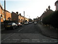
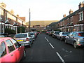
1
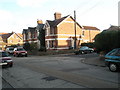
Junction of Linden Road and East Ham Road
Image: © Basher Eyre
Taken: 22 Nov 2008
0.02 miles
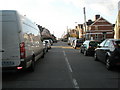
3
Junction of Gloucester Place and East Ham Road
Image: © Basher Eyre
Taken: 22 Nov 2008
0.02 miles
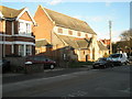
4
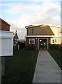
Church hall of St James the Great, East Ham Road
Image: © Basher Eyre
Taken: 22 Nov 2008
0.03 miles
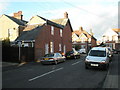
5
Junction of East Ham Road and Gloucester Lane
Image: © Basher Eyre
Taken: 22 Nov 2008
0.03 miles
7
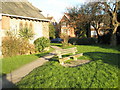
Seat in the churchyard of St James the Great, East Ham Road
Image: © Basher Eyre
Taken: 22 Nov 2008
0.04 miles
8
Crossroads of Linden Road and Gloucester Place
Image: © Basher Eyre
Taken: 22 Nov 2008
0.05 miles
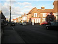
10
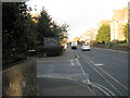
Junction of Arundel and East Ham Roads
Image: © Basher Eyre
Taken: 22 Nov 2008
0.05 miles