IMAGES TAKEN NEAR TO
Jasmine Close, LITTLEHAMPTON, BN17 6UP
Introduction
This page details the photographs taken nearby to Jasmine Close, BN17 6UP by members of the Geograph project.
The Geograph project started in 2005 with the aim of publishing, organising and preserving representative images for every square kilometre of Great Britain, Ireland and the Isle of Man.

There are currently over 7.5m images from over14,400 individuals and you can help contribute to the project by visiting https://www.geograph.org.uk
Image Map
Images are licensed for reuse under creativecommons.org/licenses/by-sa/2.0
Notes
- Clicking on the map will re-center to the selected point.
- The higher the marker number, the further away the image location is from the centre of the postcode.
Image Listing (8 Images Found)
Images are licensed for reuse under creativecommons.org/licenses/by-sa/2.0
Image
Details
Distance
2
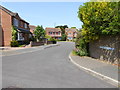
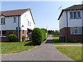
Brookfield Park
Cycle track & footpath adjacent to new housing estate.
Image: © Peter Holmes
Taken: 19 Nov 2007
0.17 miles

5
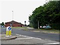
Roundabout on Worthing Road, Littlehampton
Image: © David Howard
Taken: 23 Jun 2018
0.22 miles
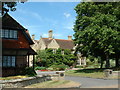
6
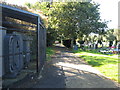
Footpath 3105 is the western boundary for Littlehampton cemetery
Image: © Dave Spicer
Taken: 29 Sep 2012
0.22 miles
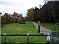
8
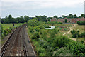
View from bridge BLI1 467D
The area on the right is part of Brookfield Park, where new housing development has been created within a semi-wild, semi-formal park area, which seems to work very well. According to the nameplate, the viewpoint bridge is 17 miles 3 chains from wherever local measurements start, probably a junction outside Brighton station.
Image: © Robin Webster
Taken: 2 Jul 2010
0.24 miles