IMAGES TAKEN NEAR TO
Horsham Road, LITTLEHAMPTON, BN17 6DW
Introduction
This page details the photographs taken nearby to Horsham Road, BN17 6DW by members of the Geograph project.
The Geograph project started in 2005 with the aim of publishing, organising and preserving representative images for every square kilometre of Great Britain, Ireland and the Isle of Man.

There are currently over 7.5m images from over14,400 individuals and you can help contribute to the project by visiting https://www.geograph.org.uk
Image Map
Images are licensed for reuse under creativecommons.org/licenses/by-sa/2.0
Notes
- Clicking on the map will re-center to the selected point.
- The higher the marker number, the further away the image location is from the centre of the postcode.
Image Listing (13 Images Found)
Images are licensed for reuse under creativecommons.org/licenses/by-sa/2.0
Image
Details
Distance
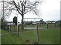
2
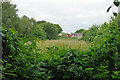
Cemetery buffer zone
This long strip of land is bordered by Littlehampton Cemetery on the left, and the back gardens of fairly new housing development on the right. There is an opening in the cemetery fence near the far end, where it is used as a cemetery soil dump and similar. It probably was secured in the event of the cemetery needing an extended area.
Image: © Robin Webster
Taken: 2 Jul 2010
0.13 miles
3
Littlehampton to Rustington and back (126)
Looking from Southfields Road into Falkland Avenue.
Image: © Basher Eyre
Taken: 18 Mar 2011
0.18 miles
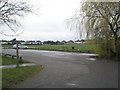
4
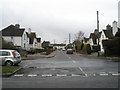
Littlehampton to Rustington and back (125)
Staggered crossroads in Southfields Road.
To the left Parkside Avenue; to the right Falkland Avenue.
Image: © Basher Eyre
Taken: 18 Mar 2011
0.19 miles
5
Littlehampton to Rustington and back (124)
Playpark in Southfields Road.
Image: © Basher Eyre
Taken: 18 Mar 2011
0.19 miles
6
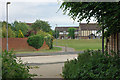
Footpath crossing at Timberleys
The footpath starts at Horsham Road, and takes a straight course until here, when an erratic route is threaded through this area of fairly new development.
Image: © Robin Webster
Taken: 2 Jul 2010
0.20 miles
7
Littlehampton to Rustington and back (122)
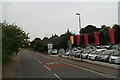
Carpark for the rec in Southfields Road.
Image: © Basher Eyre
Taken: 18 Mar 2011
0.21 miles
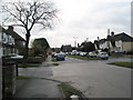
8
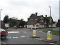
Littlehampton to Rustington and back (127)
Mini-roundabout at the western end of Southfields Road.
Image: © Basher Eyre
Taken: 18 Mar 2011
0.21 miles
9
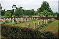
War graves, Littlehampton cemetery
The front row of 13, set somewhat apart, are German. One of these is unidentified.
Image: © Robin Webster
Taken: 2 Jul 2010
0.22 miles
10
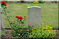
Ein Deutscher Soldat
One of 13 German war graves in Littlehampton cemetery, the only one unidentified.
Image: © Robin Webster
Taken: 2 Jul 2010
0.23 miles