IMAGES TAKEN NEAR TO
High Street, LITTLEHAMPTON, BN17 5ED
Introduction
This page details the photographs taken nearby to High Street, BN17 5ED by members of the Geograph project.
The Geograph project started in 2005 with the aim of publishing, organising and preserving representative images for every square kilometre of Great Britain, Ireland and the Isle of Man.

There are currently over 7.5m images from over14,400 individuals and you can help contribute to the project by visiting https://www.geograph.org.uk
Image Map
Images are licensed for reuse under creativecommons.org/licenses/by-sa/2.0
Notes
- Clicking on the map will re-center to the selected point.
- The higher the marker number, the further away the image location is from the centre of the postcode.
Image Listing (523 Images Found)
Images are licensed for reuse under creativecommons.org/licenses/by-sa/2.0
Image
Details
Distance
1
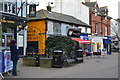
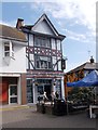
The Home & Colonial Stores & The Contented Pig - High Street
Image: © Betty Longbottom
Taken: 17 Apr 2015
0.01 miles
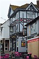
4
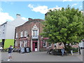
My first ever seaside visit re-traced (101)
The Crown
Image: © Basher Eyre
Taken: 11 Jul 2020
0.01 miles

7
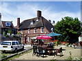
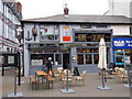
Beer garden at The Dolphin
A centrally located bar with a very large collection of WW2 memorabilia and a pianist who plays at lunchtimes, four times a week, all the old sing-a-long favourites.
Image: © Peter Holmes
Taken: 8 Jul 2010
0.01 miles
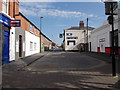
10
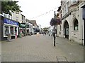
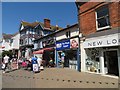
Littlehampton High Street
Pedestrianised, connecting Arundel Road and Beach Road.
Image: © Mike Faherty
Taken: 18 Aug 2018
0.02 miles