IMAGES TAKEN NEAR TO
Pier Road, LITTLEHAMPTON, BN17 5BA
Introduction
This page details the photographs taken nearby to Pier Road, BN17 5BA by members of the Geograph project.
The Geograph project started in 2005 with the aim of publishing, organising and preserving representative images for every square kilometre of Great Britain, Ireland and the Isle of Man.

There are currently over 7.5m images from over14,400 individuals and you can help contribute to the project by visiting https://www.geograph.org.uk
Image Map
Images are licensed for reuse under creativecommons.org/licenses/by-sa/2.0
Notes
- Clicking on the map will re-center to the selected point.
- The higher the marker number, the further away the image location is from the centre of the postcode.
Image Listing (592 Images Found)
Images are licensed for reuse under creativecommons.org/licenses/by-sa/2.0
Image
Details
Distance
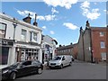
3
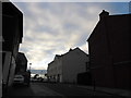
Approaching the junction of Pier and New Roads
Image: © Basher Eyre
Taken: 7 Dec 2013
0.01 miles
4
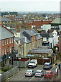
Car park and housing in Littlehampton, West Sussex
Seen from the tower of the riverside visitor centre.
Image: © Roger D Kidd
Taken: 31 Dec 2014
0.01 miles
5
My first ever seaside visit re-traced (105)
Looking southwards in Surrey Street
Image: © Basher Eyre
Taken: 11 Jul 2020
0.01 miles
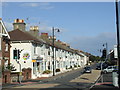
6
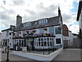
My first ever seaside visit re-traced (106)
The White Hart
Image: © Basher Eyre
Taken: 11 Jul 2020
0.01 miles
7
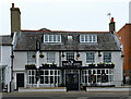
Littlehampton : "The White Hart" public house
Image: © Jim Osley
Taken: 11 Feb 2022
0.02 miles
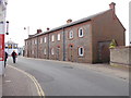
9
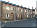
Floyd's Cottages at the bottom end of Surrey Street
Image: © Basher Eyre
Taken: 22 Nov 2008
0.02 miles
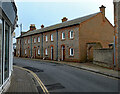
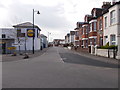
10
New Road, Littlehampton
New Road in Littlehampton.
Image: © Malc McDonald
Taken: 30 Aug 2010
0.02 miles