IMAGES TAKEN NEAR TO
South Road Mews, South Road, BRIGHTON, BN1 6ZD
Introduction
This page details the photographs taken nearby to South Road Mews, South Road, BN1 6ZD by members of the Geograph project.
The Geograph project started in 2005 with the aim of publishing, organising and preserving representative images for every square kilometre of Great Britain, Ireland and the Isle of Man.

There are currently over 7.5m images from over14,400 individuals and you can help contribute to the project by visiting https://www.geograph.org.uk
Image Map
Images are licensed for reuse under creativecommons.org/licenses/by-sa/2.0
Notes
- Clicking on the map will re-center to the selected point.
- The higher the marker number, the further away the image location is from the centre of the postcode.
Image Listing (326 Images Found)
Images are licensed for reuse under creativecommons.org/licenses/by-sa/2.0
Image
Details
Distance
1
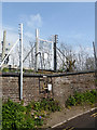
Railway access at Preston Park Junction
The paper notices advise the access is no longer to be used.
Image: © Robin Webster
Taken: 13 Apr 2019
0.03 miles
2
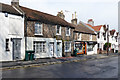
Flint buildings, South Road, Preston, Brighton
Image: © Robin Webster
Taken: 13 Apr 2019
0.03 miles
3
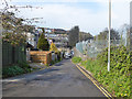
Lane behind houses on Millers Road
The railway is on the right.
Image: © Robin Webster
Taken: 13 Apr 2019
0.04 miles
4
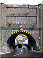
Railway bridge VTB3 181, The Drove, Brighton
Headroom 3.7 m (12'-0"), but as may be seen, a good deal more at the other end.
Image: © Robin Webster
Taken: 13 Apr 2019
0.04 miles
5
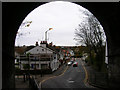
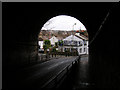
South Road, Preston
Taken from the opposite pavement to Image this time viewing down South Road towards the junction with the A23. Beyond it the 13th century church and Preston Manor can be seen. South Road is the original village boundary formerly known as South Street. The ancient east-west droveway would have run to the left and down Middle Road which is out of the picture.
Image: © Simon Carey
Taken: 24 Nov 2007
0.05 miles
6
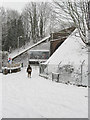
Home Road
The snow obscures the fact that road has been blocked off to prevent it becoming a little ratrun to avoid the traffic lights in the centre of Preston village. The bridge carries South Road under the London-Brighton mainline.
Image: © Simon Carey
Taken: 2 Feb 2009
0.05 miles
8
Railway Bridge - The Drove
Just south of Preston Park station
Image: © Paul Gillett
Taken: 26 Mar 2011
0.05 miles
9
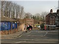
South Road, Preston
Taken from the bridge that goes under the main London-Brighton railway line. South Road (formerly Street) makes the southern boundary of the village of Preston that has long since been swallowed up by the growing conurbation of Brighton and Hove. South Street began opposite here Image] goes under the bridge then climbs Image The older ancient droveway would have extended to the Downs near Hangleton.
Image: © Simon Carey
Taken: 11 Feb 2006
0.05 miles
10
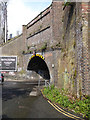
Railway bridge VTB3 181, The Drove, Brighton
Headroom 3.7 m (12'-0").
Image: © Robin Webster
Taken: 13 Apr 2019
0.05 miles