IMAGES TAKEN NEAR TO
London Road, BRIGHTON, BN1 6YQ
Introduction
This page details the photographs taken nearby to London Road, BN1 6YQ by members of the Geograph project.
The Geograph project started in 2005 with the aim of publishing, organising and preserving representative images for every square kilometre of Great Britain, Ireland and the Isle of Man.

There are currently over 7.5m images from over14,400 individuals and you can help contribute to the project by visiting https://www.geograph.org.uk
Image Map
Images are licensed for reuse under creativecommons.org/licenses/by-sa/2.0
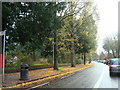
Notes
- Clicking on the map will re-center to the selected point.
- The higher the marker number, the further away the image location is from the centre of the postcode.
Image Listing (63 Images Found)
Images are licensed for reuse under creativecommons.org/licenses/by-sa/2.0
Image
Details
Distance
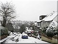
3
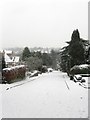
Cedars Gardens
Cul-de-sac with pedestrian exit into Snakey Lane.
Image: © Peter Holmes
Taken: 18 Jan 2014
0.05 miles
4
Cedars Gardens, Withdean
A cul de sac that lies between the A23 and the path known as Image which runs parallel to the railway. This view is from a small footpath that links the latter two at the western end of the road.
Image: © Simon Carey
Taken: 20 Jan 2013
0.05 miles
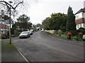
5
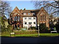
Withdean Court Avenue, Withdean
A cul de sac that lies between the A23 and Image which runs parallel with the railway. The close was built in the 1920s in the grounds of a former Victorian house called Withdean Court.
Image: © Simon Carey
Taken: 20 Jan 2013
0.08 miles
6
Withdean Court Avenue
Cul-de-sac with pedestrian exit into Snakey Lane.
Image: © Peter Holmes
Taken: 18 Jan 2014
0.09 miles
7
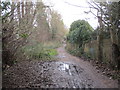
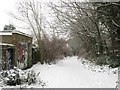
Muddy track adjacent to railway line
Snakey Lane aka Station Road.
Image: © Peter Holmes
Taken: 18 Jan 2014
0.09 miles
8
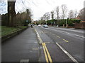
London Road, A23
Cycle track and bus stop for Brighton & Hove service 5 to Patcham.
Image: © Peter Holmes
Taken: 18 Jan 2014
0.10 miles
9
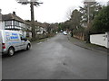
Snakey Lane
The local name given to this track that runs from Preston Park station to Withdean Road. On a number maps it seems to be designated as an extension of Station Road. Vehicles are barred though pedestrians and cyclists often use it.
Image: © Simon Carey
Taken: 20 Jan 2013
0.10 miles
10
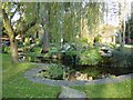
Varndean Drive ornamental pond
This pond, just yards from the A23 trunk road, is stocked with beautiful koi carp.
Image: © Brian Dungate
Taken: 9 Dec 2006
0.11 miles