IMAGES TAKEN NEAR TO
Parkmore Terrace, BRIGHTON, BN1 6AL
Introduction
This page details the photographs taken nearby to Parkmore Terrace, BN1 6AL by members of the Geograph project.
The Geograph project started in 2005 with the aim of publishing, organising and preserving representative images for every square kilometre of Great Britain, Ireland and the Isle of Man.

There are currently over 7.5m images from over14,400 individuals and you can help contribute to the project by visiting https://www.geograph.org.uk
Image Map
Images are licensed for reuse under creativecommons.org/licenses/by-sa/2.0
Notes
- Clicking on the map will re-center to the selected point.
- The higher the marker number, the further away the image location is from the centre of the postcode.
Image Listing (329 Images Found)
Images are licensed for reuse under creativecommons.org/licenses/by-sa/2.0
Image
Details
Distance
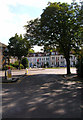
1

Parkmore Terrace
Small cul-de-sac off Dyke Road Drive backing onto the railway. Developed in the early 1880s.
Image: © Simon Carey
Taken: 27 Aug 2007
0.01 miles
2

Dyke Road Drive
The lower portion of the road that links Preston Road with the area known as Port Hall. Developed in the early 1880s as the road was cut into the hill, the concrete walls to the left mark the boundary of the railway's land.
Image: © Simon Carey
Taken: 27 Aug 2007
0.03 miles


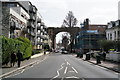
5

Plumb Building Yard
Underneath one of the giant arches of the viaduct that carries the Brighton-Hastings line opened in 1846. The viaduct originally stood in open countryside but by the 1880s was surrounded by houses. The next arch to the right was hit by a bomb in World War Two. Taken from the end of Campbell Road.
Image: © Simon Carey
Taken: 27 Aug 2007
0.05 miles
6

City College, Preston Road
Main building for the plumbing and building courses in the shadow of the viaduct.
Image: © Simon Carey
Taken: 27 Aug 2007
0.05 miles
7
Houses on Preston Road
Taken from Preston Park Avenue and looking toward the junction on the A23 that sends southbound traffic up Stanford Avenue and receives northbound traffic up Preston Road. Both start or end at Preston Circus. The houses were constructed in the late 1870s.
Image: © Simon Carey
Taken: 27 Aug 2007
0.05 miles
8
Brighton
Preston Road, looking towards the railway viaduct.
Image: © Peter Trimming
Taken: 9 Mar 2020
0.05 miles
9

Brighton City College - Preston Road Campus
Image: © N Chadwick
Taken: 3 Jul 2015
0.06 miles
10

Brighton City College - Preston Road Campus
Image: © N Chadwick
Taken: 3 Jul 2015
0.06 miles