IMAGES TAKEN NEAR TO
Watson Grove, LITTLEHAMPTON, BN16 4PF
Introduction
This page details the photographs taken nearby to Watson Grove, BN16 4PF by members of the Geograph project.
The Geograph project started in 2005 with the aim of publishing, organising and preserving representative images for every square kilometre of Great Britain, Ireland and the Isle of Man.

There are currently over 7.5m images from over14,400 individuals and you can help contribute to the project by visiting https://www.geograph.org.uk
Image Map
Images are licensed for reuse under creativecommons.org/licenses/by-sa/2.0
Notes
- Clicking on the map will re-center to the selected point.
- The higher the marker number, the further away the image location is from the centre of the postcode.
Image Listing (20 Images Found)
Images are licensed for reuse under creativecommons.org/licenses/by-sa/2.0
Image
Details
Distance
1
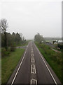
Angmering By-Pass
The by-pass, the A280, was opened in 2003 to relieve the heavily congested narrow roads of Angmering village centre. Taken from the footbridge opened at the same time with Manor Nurseries to the right and the junction with Ecclesden Lane to the left.
Image: © Simon Carey
Taken: 13 Apr 2009
0.06 miles
2
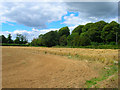
Field, Roundstone Farm
The farm is a pick your own establishment and appears to operate where strips of the same field is used for growing different produce. Here a small section of wheat abuts Ecclesden Lane to the north and the A280 to the West. Taken from the footpath that links Ecclesden Lane to the A259.
Image: © Simon Carey
Taken: 20 Jul 2008
0.09 miles
3
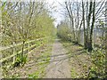
Angmering, byway
Running parallel to A280, from Angmering High Street to A259.
Image: © Mike Faherty
Taken: 13 Apr 2019
0.10 miles
4
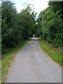
Ecclesden Lane
I think this may be a private drive though it is a public bridleway that leads to Ecclesden Mill from the main A280. Ecclesden Manor beyond the trees to the right. Taken from the junction with oa footpath that heads south to the A259.
Image: © Simon Carey
Taken: 20 Jul 2008
0.10 miles
5
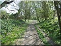
Angmering, byway
Running parallel to A280, from Angmering High Street to A259.
Image: © Mike Faherty
Taken: 13 Apr 2019
0.12 miles
6
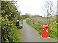
Angmering, bridleway
From the eastern end of High Street, over A280 and on to Ferring.
Image: © Mike Faherty
Taken: 13 Apr 2019
0.13 miles
7
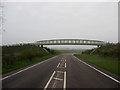
Footbridge over Angmering By-Pass
Built in 2003 to carry the bridleway over the new village by-pass. Taken just after 7am on a bank holiday about the only time to safely be able to stand in the middle of this road.
Image: © Simon Carey
Taken: 13 Apr 2009
0.13 miles
9
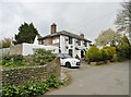
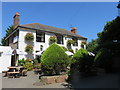
Angmering, Spotted Cow
Public house at the eastern end of High Street. Internally, a small bar right, dining left and central counter; darts, outdoor seating at front. Six cask ales on offer. The C19 building is Grade II listed by Historic England: https://historicengland.org.uk/listing/the-list/list-entry/1353862
Image: © Mike Faherty
Taken: 13 Apr 2019
0.15 miles
10
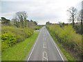
Angmering, A280
Heading South towards A259; seen from Image
Image: © Mike Faherty
Taken: 13 Apr 2019
0.15 miles