IMAGES TAKEN NEAR TO
Lloyd Goring Close, LITTLEHAMPTON, BN16 4LQ
Introduction
This page details the photographs taken nearby to Lloyd Goring Close, BN16 4LQ by members of the Geograph project.
The Geograph project started in 2005 with the aim of publishing, organising and preserving representative images for every square kilometre of Great Britain, Ireland and the Isle of Man.

There are currently over 7.5m images from over14,400 individuals and you can help contribute to the project by visiting https://www.geograph.org.uk
Image Map
Images are licensed for reuse under creativecommons.org/licenses/by-sa/2.0
Notes
- Clicking on the map will re-center to the selected point.
- The higher the marker number, the further away the image location is from the centre of the postcode.
Image Listing (11 Images Found)
Images are licensed for reuse under creativecommons.org/licenses/by-sa/2.0
Image
Details
Distance
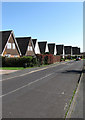
1
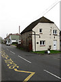
Chantryfield Road
Viewed from the junction with Arundel Road and named after a former field of that name.
Image: © Simon Carey
Taken: 13 Apr 2009
0.07 miles
2
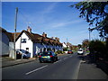
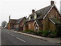
Longback Cottages, Angmering
These Cottages on Arundel Road (B2225), built in 1728 were the parish poorhouses, originally provided for the aged and infirm poor of Angmering.
Image: © Peter Holmes
Taken: 12 Nov 2007
0.16 miles
3
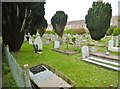
Angmering, graveyard
Off Arundel Road, attached to St. Wilfrid's RC Church.
Image: © Mike Faherty
Taken: 13 Apr 2019
0.19 miles
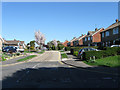
4
Beech View
Residential street link Chantryfield Road and Merryfield Crescent.
Image: © Simon Carey
Taken: 13 Apr 2009
0.20 miles
5
The Old Forge House, Arundel Road
Opposite St Wilfred's Roman Catholic Primary School.
Image: © Simon Carey
Taken: 13 Apr 2009
0.22 miles
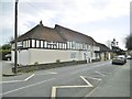
6
St Wilfred's Roman Catholic Primary School
Originally built with the Catholic church in 1872 with funds provided by the Duke of Norfolk. The church on the left closed in the 1990s though the grounds were taken over by the school and new buildings built to the rear in 2004. Consequently, the original school building on the right was vacated and is now an empty shell awaiting a purchaser. Both are on Arundel Road.
Image: © Simon Carey
Taken: 13 Apr 2009
0.23 miles
7
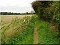
Footpath 2176 from Angmering to Arundel Road (A27)
Well used by dog walkers.
Image: © Peter Holmes
Taken: 15 Aug 2009
0.23 miles
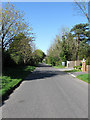
8
Angmering: Water Lane
Prior to the development of the housing on the left side of the lane here, the watercourse known as Black Ditch used to run down the side of the road. Nowadays it is culverted throughout Angmering. The Ordnance Survey map of 1938 shows the area to the left in use as allotment gardens.
Image: © Nigel Cox
Taken: 17 Sep 2009
0.23 miles
9
Angmering, Aberdeen House
On Arundel Road. C18 building, once a butcher's shop, now residential. Grade II listed by Historic England: https://historicengland.org.uk/listing/the-list/list-entry/1027712
Image: © Mike Faherty
Taken: 13 Apr 2019
0.23 miles
10
Dappers Lane
Lane that once linked Water Lane with the A27 but now allows access to Patching only.
Image: © Simon Carey
Taken: 13 Apr 2009
0.24 miles