IMAGES TAKEN NEAR TO
East Drive, LITTLEHAMPTON, BN16 4JH
Introduction
This page details the photographs taken nearby to East Drive, BN16 4JH by members of the Geograph project.
The Geograph project started in 2005 with the aim of publishing, organising and preserving representative images for every square kilometre of Great Britain, Ireland and the Isle of Man.

There are currently over 7.5m images from over14,400 individuals and you can help contribute to the project by visiting https://www.geograph.org.uk
Image Map
Images are licensed for reuse under creativecommons.org/licenses/by-sa/2.0
Notes
- Clicking on the map will re-center to the selected point.
- The higher the marker number, the further away the image location is from the centre of the postcode.
Image Listing (5 Images Found)
Images are licensed for reuse under creativecommons.org/licenses/by-sa/2.0
Image
Details
Distance
1
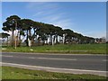
Row of Fir Trees
This row of fir trees is south of the golf club and east of the superstore and situated in the lower half and slightly into the western section of the grid square.
Image: © Pam Brophy
Taken: 16 Apr 2005
0.11 miles
2
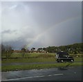
Rainbow over Ham Manor
Taken from Rustington Bypass
Image: © Nikki Plumb
Taken: Unknown
0.18 miles
3

Looking across the grounds of Angmering School
Image: © Shazz
Taken: 3 Dec 2015
0.20 miles
4
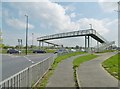
Angmering, footbridge
Carrying pedestrians on Station Road over A259.
Image: © Mike Faherty
Taken: 13 Apr 2019
0.23 miles
5
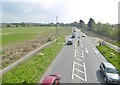
Angmering, A259
Traffic towards Worthing and Brighton is building up. Seen from Image
Image: © Mike Faherty
Taken: 13 Apr 2019
0.23 miles