IMAGES TAKEN NEAR TO
Mill Road, LITTLEHAMPTON, BN16 4HP
Introduction
This page details the photographs taken nearby to Mill Road, BN16 4HP by members of the Geograph project.
The Geograph project started in 2005 with the aim of publishing, organising and preserving representative images for every square kilometre of Great Britain, Ireland and the Isle of Man.

There are currently over 7.5m images from over14,400 individuals and you can help contribute to the project by visiting https://www.geograph.org.uk
Image Map
Images are licensed for reuse under creativecommons.org/licenses/by-sa/2.0
Notes
- Clicking on the map will re-center to the selected point.
- The higher the marker number, the further away the image location is from the centre of the postcode.
Image Listing (48 Images Found)
Images are licensed for reuse under creativecommons.org/licenses/by-sa/2.0
Image
Details
Distance
2
Angmering Baptist Church
On Station Road, replacing Image, to the North: http://www.angmeringbaptist.org.uk/all-about-us/
Image: © Mike Faherty
Taken: 13 Apr 2019
0.08 miles
4
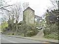
Angmering, Old Baptist Church
On Station Road, the precursor to Image Early C19, with an unusual tower; Grade II listed by Historic England: https://historicengland.org.uk/listing/the-list/list-entry/1027686
Image: © Mike Faherty
Taken: 13 Apr 2019
0.10 miles
7
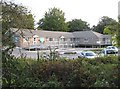
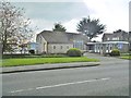
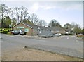
Angmering Medical Centre
Viewed from The Thatchway the surgery was opened in 2006. The part of the building to the right is actually raised on concrete columns almost certainly because of the flood risk from the nearby Black Ditch.
Image: © Nigel Cox
Taken: 17 Sep 2009
0.13 miles
8
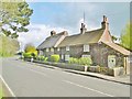
Angmering, cottages
A pair of cottages on Station Road: left (thatched roof), Old Mill House; right (tiled roof) Old Cottage. C18, Grade II listed by Historic England: https://historicengland.org.uk/listing/the-list/list-entry/1233050
Image: © Mike Faherty
Taken: 13 Apr 2019
0.14 miles
9
Angmering Medical Centre
On Station Road, with pharmacy: http://www.angmeringmedicalcentre.nhs.uk/index.aspx
Image: © Mike Faherty
Taken: 13 Apr 2019
0.14 miles
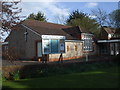
10
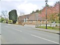
Angmering Village Hall
On Station Road: http://angmeringvillagehall.btck.co.uk/
Image: © Mike Faherty
Taken: 13 Apr 2019
0.16 miles