IMAGES TAKEN NEAR TO
Chantryfield Road, LITTLEHAMPTON, BN16 4DH
Introduction
This page details the photographs taken nearby to Chantryfield Road, BN16 4DH by members of the Geograph project.
The Geograph project started in 2005 with the aim of publishing, organising and preserving representative images for every square kilometre of Great Britain, Ireland and the Isle of Man.

There are currently over 7.5m images from over14,400 individuals and you can help contribute to the project by visiting https://www.geograph.org.uk
Image Map
Images are licensed for reuse under creativecommons.org/licenses/by-sa/2.0
Notes
- Clicking on the map will re-center to the selected point.
- The higher the marker number, the further away the image location is from the centre of the postcode.
Image Listing (6 Images Found)
Images are licensed for reuse under creativecommons.org/licenses/by-sa/2.0
Image
Details
Distance
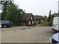
1
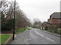
Beech View
Residential street link Chantryfield Road and Merryfield Crescent.
Image: © Simon Carey
Taken: 13 Apr 2009
0.04 miles
2
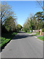
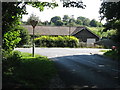
Dappers Lane
Lane that once linked Water Lane with the A27 but now allows access to Patching only.
Image: © Simon Carey
Taken: 13 Apr 2009
0.06 miles
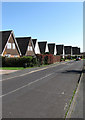
3
Chantryfield Road
Viewed from the junction with Arundel Road and named after a former field of that name.
Image: © Simon Carey
Taken: 13 Apr 2009
0.23 miles
4
A rainy new year's day in Angmering
Looking east along Water Lane in the rain near midday on new year's day 2014.
Image: © Roger Jones
Taken: 1 Jan 2014
0.24 miles
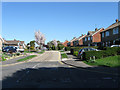
5
Dapper's Lane junction with Water Lane Angmering
Image: © Dave Spicer
Taken: 20 Aug 2012
0.25 miles