IMAGES TAKEN NEAR TO
Ascot Way, LITTLEHAMPTON, BN16 3SB
Introduction
This page details the photographs taken nearby to Ascot Way, BN16 3SB by members of the Geograph project.
The Geograph project started in 2005 with the aim of publishing, organising and preserving representative images for every square kilometre of Great Britain, Ireland and the Isle of Man.

There are currently over 7.5m images from over14,400 individuals and you can help contribute to the project by visiting https://www.geograph.org.uk
Image Map
Images are licensed for reuse under creativecommons.org/licenses/by-sa/2.0
Notes
- Clicking on the map will re-center to the selected point.
- The higher the marker number, the further away the image location is from the centre of the postcode.
Image Listing (140 Images Found)
Images are licensed for reuse under creativecommons.org/licenses/by-sa/2.0
Image
Details
Distance
1
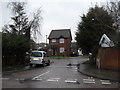
Looking from Ascot Way into Crunden's Close
Image: © Basher Eyre
Taken: 16 Jan 2010
0.01 miles

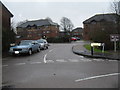
4
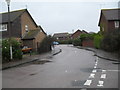
Junction of Crunden's Corner and Ascot Way
Image: © Basher Eyre
Taken: 16 Jan 2010
0.01 miles
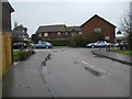
5
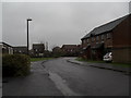
Mid section of Ascot Way during heavy rain
Image: © Basher Eyre
Taken: 16 Jan 2010
0.02 miles
6
Looking from Ascot Way into Copper Hall Close
Image: © Basher Eyre
Taken: 16 Jan 2010
0.03 miles
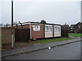
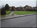
9
An empty surgery car park in Sheepfold Avenue
Either there are no unhealthy people in Angmering; or their docs don't do Saturday mornings.
Image: © Basher Eyre
Taken: 16 Jan 2010
0.03 miles
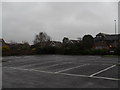
10
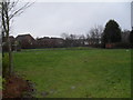
An unsurprisingly empty playpark off Ascot Close
Image: © Basher Eyre
Taken: 16 Jan 2010
0.04 miles