IMAGES TAKEN NEAR TO
Winchester Road, LITTLEHAMPTON, BN16 3RH
Introduction
This page details the photographs taken nearby to Winchester Road, BN16 3RH by members of the Geograph project.
The Geograph project started in 2005 with the aim of publishing, organising and preserving representative images for every square kilometre of Great Britain, Ireland and the Isle of Man.

There are currently over 7.5m images from over14,400 individuals and you can help contribute to the project by visiting https://www.geograph.org.uk
Image Map
Images are licensed for reuse under creativecommons.org/licenses/by-sa/2.0
Notes
- Clicking on the map will re-center to the selected point.
- The higher the marker number, the further away the image location is from the centre of the postcode.
Image Listing (101 Images Found)
Images are licensed for reuse under creativecommons.org/licenses/by-sa/2.0
Image
Details
Distance
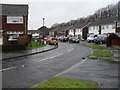
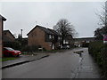
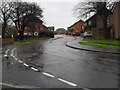
4
Looking from Winchester Road into Guildford Road
Image: © Basher Eyre
Taken: 16 Jan 2010
0.02 miles
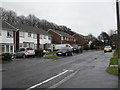
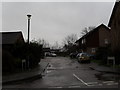
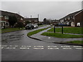
5
Approaching the junction of Ascot Way and Guildford Road
Image: © Basher Eyre
Taken: 16 Jan 2010
0.03 miles
7
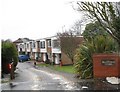
Burmill Mews at the far end of Angmering Way
Image: © Basher Eyre
Taken: 16 Jan 2010
0.04 miles
8
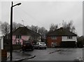
"Banjo" at the end of Angmering Way
I have also heard them called frying pans or tennis racquet.
Image: © Basher Eyre
Taken: 16 Jan 2010
0.05 miles
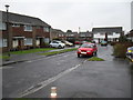
9
Looking from Winchester Road along Guildord Road towards Ascot Way
Image: © Basher Eyre
Taken: 16 Jan 2010
0.05 miles
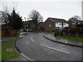
10
Looking from Guildford Road into Canterbury Road
Image: © Basher Eyre
Taken: 16 Jan 2010
0.05 miles