IMAGES TAKEN NEAR TO
Brookside Avenue, LITTLEHAMPTON, BN16 3LP
Introduction
This page details the photographs taken nearby to Brookside Avenue, BN16 3LP by members of the Geograph project.
The Geograph project started in 2005 with the aim of publishing, organising and preserving representative images for every square kilometre of Great Britain, Ireland and the Isle of Man.

There are currently over 7.5m images from over14,400 individuals and you can help contribute to the project by visiting https://www.geograph.org.uk
Image Map
Images are licensed for reuse under creativecommons.org/licenses/by-sa/2.0
Notes
- Clicking on the map will re-center to the selected point.
- The higher the marker number, the further away the image location is from the centre of the postcode.
Image Listing (9 Images Found)
Images are licensed for reuse under creativecommons.org/licenses/by-sa/2.0
Image
Details
Distance
2
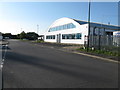
Industrial unit on Artex Avenue
On the Brookside Industrial Estate.
Image: © Dave Spicer
Taken: 20 Aug 2012
0.05 miles
4
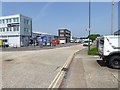
Petrol station on Worthing Road seen from footpath junction
The footpath is known as Penfold Lane.
Image: © Shazz
Taken: 29 May 2016
0.18 miles
6
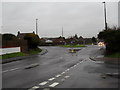
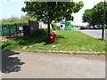
Looking from Windmill Drive towards the Worthing Road roundabout
Image: © Basher Eyre
Taken: 16 Jan 2010
0.21 miles
7
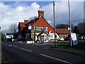
The Windmill, Rustington
Popular local with large garden situated in Mill Lane (B2187).
Image: © Peter Holmes
Taken: 19 Nov 2007
0.21 miles
8
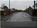
Looking from Mill Lane into Albert Road
Image: © Basher Eyre
Taken: 16 Jan 2010
0.24 miles
9
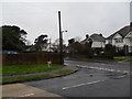
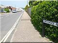
Junction of Windmill Drive and Mill Lane
Image: © Basher Eyre
Taken: 16 Jan 2010
0.24 miles