IMAGES TAKEN NEAR TO
Eastcourt Way, LITTLEHAMPTON, BN16 3JF
Introduction
This page details the photographs taken nearby to Eastcourt Way, BN16 3JF by members of the Geograph project.
The Geograph project started in 2005 with the aim of publishing, organising and preserving representative images for every square kilometre of Great Britain, Ireland and the Isle of Man.

There are currently over 7.5m images from over14,400 individuals and you can help contribute to the project by visiting https://www.geograph.org.uk
Image Map
Images are licensed for reuse under creativecommons.org/licenses/by-sa/2.0
Notes
- Clicking on the map will re-center to the selected point.
- The higher the marker number, the further away the image location is from the centre of the postcode.
Image Listing (73 Images Found)
Images are licensed for reuse under creativecommons.org/licenses/by-sa/2.0
Image
Details
Distance
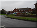
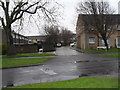
1
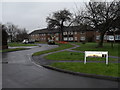
Looking from East Court Way into Allangate Drive
Image: © Basher Eyre
Taken: 16 Jan 2010
0.01 miles
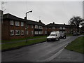
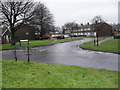
2
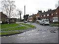
Looking from Allangate Drive into East Court Way
Image: © Basher Eyre
Taken: 16 Jan 2010
0.01 miles
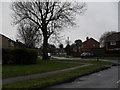
4
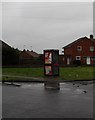
Telephone box at the southern end of Lawrence Avenue
Image: © Basher Eyre
Taken: 16 Jan 2010
0.04 miles
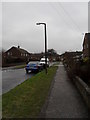
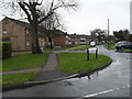
5
Approaching the junction of Allangate Drive and Lawrence Avenue
Image: © Basher Eyre
Taken: 16 Jan 2010
0.04 miles
7
Looking from Canterbury Road into Allangate Drive
Image: © Basher Eyre
Taken: 16 Jan 2010
0.05 miles
8
Looking from Canterbury Road towards the junction of Allangate Drive and Richmond Close
Image: © Basher Eyre
Taken: 16 Jan 2010
0.06 miles
9
Looking from Allangate Drive into Richmond Close
Image: © Basher Eyre
Taken: 16 Jan 2010
0.06 miles
10
Looking from Allangate Drive into Richmond Close
Image: © Basher Eyre
Taken: 16 Jan 2010
0.07 miles