IMAGES TAKEN NEAR TO
The Roystons, LITTLEHAMPTON, BN16 2TS
Introduction
This page details the photographs taken nearby to The Roystons, BN16 2TS by members of the Geograph project.
The Geograph project started in 2005 with the aim of publishing, organising and preserving representative images for every square kilometre of Great Britain, Ireland and the Isle of Man.

There are currently over 7.5m images from over14,400 individuals and you can help contribute to the project by visiting https://www.geograph.org.uk
Image Map
Images are licensed for reuse under creativecommons.org/licenses/by-sa/2.0
Notes
- Clicking on the map will re-center to the selected point.
- The higher the marker number, the further away the image location is from the centre of the postcode.
Image Listing (19 Images Found)
Images are licensed for reuse under creativecommons.org/licenses/by-sa/2.0
Image
Details
Distance
1
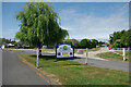
Way in, Willowhayne private estate, East Preston
Image: © Robin Webster
Taken: 2 Jul 2010
0.09 miles
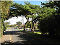
3
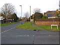
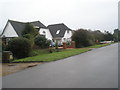
Looking south on Sea Lane
For a summer view see http://www.geograph.org.uk/photo/3590989.
Image: © Shazz
Taken: 3 Dec 2015
0.15 miles
5
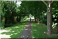
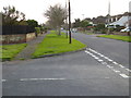
Public footpath East Preston 2144
Running from Sea Road to Sea Lane.
Image: © Robin Webster
Taken: 2 Jul 2010
0.17 miles
6
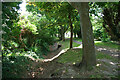
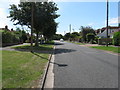
Ditch parallel with footpath East Preston 2144
Warren Recreation Ground is to the left.
Image: © Robin Webster
Taken: 2 Jul 2010
0.19 miles
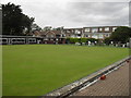
10
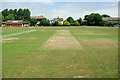
Cricket pitch, East Preston
The pavilion at the left is being used by a play group, although all seem to be outside on this very warm July day.
Image: © Robin Webster
Taken: 2 Jul 2010
0.21 miles