IMAGES TAKEN NEAR TO
West Ridings, LITTLEHAMPTON, BN16 2TD
Introduction
This page details the photographs taken nearby to West Ridings, BN16 2TD by members of the Geograph project.
The Geograph project started in 2005 with the aim of publishing, organising and preserving representative images for every square kilometre of Great Britain, Ireland and the Isle of Man.

There are currently over 7.5m images from over14,400 individuals and you can help contribute to the project by visiting https://www.geograph.org.uk
Image Map
Images are licensed for reuse under creativecommons.org/licenses/by-sa/2.0
Notes
- Clicking on the map will re-center to the selected point.
- The higher the marker number, the further away the image location is from the centre of the postcode.
Image Listing (13 Images Found)
Images are licensed for reuse under creativecommons.org/licenses/by-sa/2.0
Image
Details
Distance
1
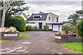
Vista Point
House on Tamarisk Way in the Willowhayne Estate. The building was designed by Patrick Gwynne and completed in 1970. It is described in The Buildings of England: Susses, West as "a more organic reprise, in technologically advanced materials, of South Cost Modern Movement houses". Grade II listed - see www.historicengland.org.uk/listing/the-list/list-entry/1396577.
Image: © Ian Capper
Taken: 26 Oct 2021
0.08 miles
2
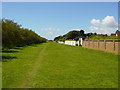
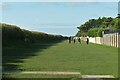
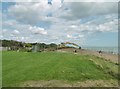
Greensward, Willowhayne Estate
Looking west. This is private land owned by the residents of the Willowhayne Estate to the north. There is a public footpath across the Greensward. Just the other side of the trees on the left is the beach.
Image: © Janine Forbes
Taken: 23 May 2005
0.11 miles
3
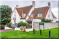
11 Tamarisk Way
House on Tamarisk Way in the Willowhayne Estate, named Laguna on the 1961 1:2,500 map. On the right is East Walk, providing a connection to South Walk and the beach.
Image: © Ian Capper
Taken: 26 Oct 2021
0.14 miles
4
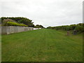
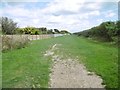
Green & Footpath by Willowhayne Estate
The Private estate is to the north (left) with the beach beyond the trees to the south
Image: © Paul Gillett
Taken: 5 Oct 2013
0.16 miles
5
The Greensward
Looking west from Sea Lane, East Preston.
Image: © Peter Jeffery
Taken: 3 Nov 2021
0.18 miles
6
East Preston, Willowhayne
A long strip of grassland between housing and the beach, with a path through the centre.
Image: © Mike Faherty
Taken: 25 Aug 2018
0.20 miles
7
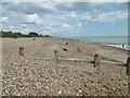
East Preston, beach & groynes
Shingle beach, with patches of sand at low tide.
Image: © Mike Faherty
Taken: 25 Aug 2018
0.20 miles
8
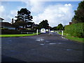
Gateway to Willowhayne private estate
Detached houses in Tamarisk Way at junction with Sea Lane,East Preston.
Image: © Peter Holmes
Taken: 19 Nov 2007
0.20 miles
9
Rustington, beach works
Judging from the new sections of pipe nearby, this is part of drainage work.
Image: © Mike Faherty
Taken: 25 Aug 2018
0.21 miles
10
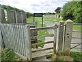
East Preston, kissing gate
At the eastern end of Image
Image: © Mike Faherty
Taken: 25 Aug 2018
0.24 miles