IMAGES TAKEN NEAR TO
Harsfold Road, LITTLEHAMPTON, BN16 2NT
Introduction
This page details the photographs taken nearby to Harsfold Road, BN16 2NT by members of the Geograph project.
The Geograph project started in 2005 with the aim of publishing, organising and preserving representative images for every square kilometre of Great Britain, Ireland and the Isle of Man.

There are currently over 7.5m images from over14,400 individuals and you can help contribute to the project by visiting https://www.geograph.org.uk
Image Map
Images are licensed for reuse under creativecommons.org/licenses/by-sa/2.0
Notes
- Clicking on the map will re-center to the selected point.
- The higher the marker number, the further away the image location is from the centre of the postcode.
Image Listing (117 Images Found)
Images are licensed for reuse under creativecommons.org/licenses/by-sa/2.0
Image
Details
Distance
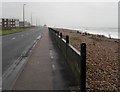
1
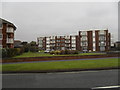
Flats with a view of Rustington Beach
Taken in Sea Road.
Image: © Basher Eyre
Taken: 16 Jan 2010
0.00 miles
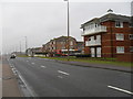
2
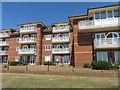
Strand Court
Accessed off Harsfold Road, built in 1997.
Image: © Fernweh
Taken: 1 Aug 2018
0.00 miles
7
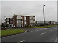
Approaching the junction of Sea Road and Marina Gardens
Image: © Basher Eyre
Taken: 16 Jan 2010
0.02 miles
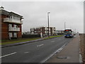
8

Looking west along Sea Road from Marama Gardens
Image: © Shazz
Taken: 29 May 2016
0.02 miles
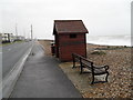
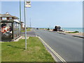
9
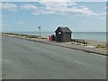
Rustington, bus shelter
On Sea Road, overlooking the beach; offering infrequent services by Compass.
Image: © Mike Faherty
Taken: 25 Aug 2018
0.03 miles
10
Bus stops on Sea Road
The bus stop on the right is also seen at http://www.geograph.org.uk/photo/1669882.
Image: © Shazz
Taken: 29 May 2016
0.03 miles