IMAGES TAKEN NEAR TO
Dolphin Way, LITTLEHAMPTON, BN16 2EW
Introduction
This page details the photographs taken nearby to Dolphin Way, BN16 2EW by members of the Geograph project.
The Geograph project started in 2005 with the aim of publishing, organising and preserving representative images for every square kilometre of Great Britain, Ireland and the Isle of Man.

There are currently over 7.5m images from over14,400 individuals and you can help contribute to the project by visiting https://www.geograph.org.uk
Image Map
Images are licensed for reuse under creativecommons.org/licenses/by-sa/2.0
Notes
- Clicking on the map will re-center to the selected point.
- The higher the marker number, the further away the image location is from the centre of the postcode.
Image Listing (88 Images Found)
Images are licensed for reuse under creativecommons.org/licenses/by-sa/2.0
Image
Details
Distance
1
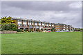
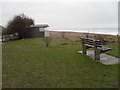
Broad Strand and Dolphin Court
c.1960s flats overlooking a coastal greensward.
Image: © Ian Capper
Taken: 26 Oct 2021
0.03 miles
4
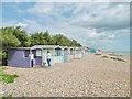
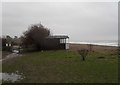
Rustington, beach huts
Overlooking the shingle beach.
Image: © Mike Faherty
Taken: 25 Aug 2018
0.04 miles
5
Looking from Broadmark Beach into Sea Avenue
Image: © Basher Eyre
Taken: 16 Jan 2010
0.04 miles
6
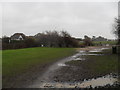
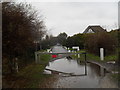
Rustington, Sea Avenue
Private road from the beach to Station Road.
Image: © Mike Faherty
Taken: 25 Aug 2018
0.04 miles
8
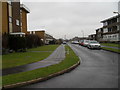
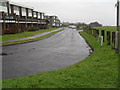
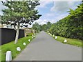
Looking from Broad Strand up Dolphin Way
Image: © Basher Eyre
Taken: 16 Jan 2010
0.05 miles
9
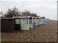
Pastel coloured beach huts on Broadmark Beach
Image: © Basher Eyre
Taken: 16 Jan 2010
0.05 miles